Lots of swell to come with periods of favourable winds
South Australian Forecast by Craig Brokensha (issued Monday 13th February)
Best Days: Keen surfers Tuesday morning down South, Wednesday, Thursday and Friday mornings down South
Recap
An average weekend of waves with lighter onshore winds across the South Coast Saturday morning with small amounts of swell, bigger but sloppy on Sunday. The Mid Coast was tiny all weekend.
Today the South Coast was larger with a building S/SW swell but conditions were again a complete mess. The Mid Coast offered a tiny junky windswell.
This week and weekend (Feb 14 – 19)
Today's building swell across the South Coast was generated by a strong and broad cold front projecting up and into Victoria, and we should see Middleton peaking around 4-5ft through this afternoon and evening.
The swell should drop away gradually over the coming days as the front continues east out of our swell window.
Middleton is looking at 3-5ft sets tomorrow morning, smaller from 3ft Wednesday morning.
The Mid Coast should be tiny tomorrow and near flat on Wednesday.
Conditions are due to improve tomorrow across both coasts with a light offshore on the Mid, and a light E/NE'ly developing down South, but Wednesday is the pick with a straight offshore N'ly wind, tending variable ahead of a change through the afternoon.
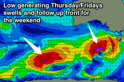
 This change will be linked to a strong mid-latitude front passing south of the Bight, on its way to Tasmania.
An initial fetch of relatively weak SW winds are expected to be generated, followed by a stronger fetch of severe-gale W/SW winds through our southern swell window Wednesday.
This will result in a strong S/SW groundswell building Thursday, peaking Friday morning.
Middleton should build to 3-5ft by dark Thursday, with 4-5ft sets early Friday morning, easing into the afternoon.
The Mid Coast should build to 1ft or so later Thursday, easing from a similar size Friday morning.
Winds Thursday morning look variable before sea breezes kick in, while Friday should provide a W/NW'ly around Victor ahead of a W/SW change.
Into the weekend another larger SW groundswell event is due from a slow moving and strong polar frontal progression.
We'll see a great fetch of SW gales projected right up and into us late week and through Saturday, generating a large SW groundswell for Saturday/Sunday but with poor S/SW winds.
More on this Wednesday though.

