Good swells for the Mid Coast continue
South Australian Forecast by Craig Brokensha (issued Monday 16th January)
Sign up to Swellnet’s newsletter and receive the South Australian Forecaster Notes and latest news sent directly to your inbox. Upon signup you'll also enter the draw to win a surf trip to P-Pass for you and a mate (there's only 2 weeks left to go). It doesn’t get much easier so click HERE to sign up now.
Best Days: South Coast Tuesday morning (Mid late in the day), Mid Coast Wednesday and Thursday morning, South Coast Thursday morning, Mid Coast over the weekend (Sunday down South)
Recap
A bit of swell about Saturday morning across both coasts but with onshore winds, while into the afternoon a large W/SW groundswell filled in, pulsing to a solid 3ft to occasionally 4ft at magnets on the Mid Coast and larger down South.
The swell peaked during the middle of the day on the Cape du Couedic wave buoy, showing some winter like figures with average wave heights just under 6m, with max wave heights reaching above 10m at peak periods of 15-16s.

Into Sunday morning the surf cleaned up with easing 2-3ft sets on the Mid Coast, albeit a little inconsistent and solid workable 3-5ft waves off Middleton during the morning.
A reinforcing S/SW groundswell arrived into the afternoon across the South Coast, and has kept good 3-4ft sets hitting into this morning, but a steady drop in size is due through this afternoon.
The Mid Coast was 1-2ft early but has also dropped away, and winds should remain favourable most of the day, tending variable this afternoon with possible weak sea breezes down South.
This week (Jan 17 - 20)
A hot offshore wind will keep the South Coast clean again tomorrow morning, but the swell will be much smaller and likely only coming in at 1-2ft across Middleton. Waits and Parsons will be the better bet, while tiny waves are due on the Mid.
An onshore change is due early-mid afternoon, so get out through the morning for the best conditions and most size.
Our new W/SW groundswell for later Tuesday and Wednesday morning is still on track, with the swell impacting Western Australia today.
This swell was generated by a broad and slow moving low in the south-east Indian Ocean late last week and Saturday.
This low has since weakened, and the remnants are moving just under WA today. A weak fetch of W/SW winds will continue to be generated through our south-western swell window this evening and tomorrow, generating a better aligned SW swell for the South Coast later Wednesday and Thursday.
But coming back to the W/SW pulse, and we should see the Mid building to 1-2ft later tomorrow with winds possibly going S/SE near dark, peaking Wednesday to a good 2ft on the favourable parts of the tide, if not for the odd sneaker. SE winds should only tend S/SE through the day, keeping conditions clean most of the day.
The South Coast Wednesday will be onshore and average with that SE breeze and small to 2ft to maybe 3ft wave at Middleton.
 The mid-period SW swell for Thursday looks better, with fun 3ft sets at Middleton and 4ft+ waves at Waits and Parsons, easing Friday. The Mid should ease from 1-2ft Thursday morning.
Conditions will be best on the South Coast Thursday morning with an E/NE-NE wind developing through the morning ahead of afternoon sea breezes, while Friday looks poor as a surface trough moves through, bringing onshore S/SW winds.
This weekend onwards (Jan 21 onwards)
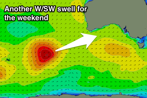
Yet another fun but slightly smaller W/SW groundswell is due over the weekend (it seems the season for it!).
A polar low forming in the Heard Island region today should project north-east towards WA while generating a fetch of gale to severe-gale SW winds through our western swell window.
The low will weaken under the South West of WA Thursday morning, leaving a good but inconsistent W/SW groundswell to head towards us.
This swell is due to build through Saturday (tiny early) reaching an infrequent 2ft on the sets across the Mid Coast into the afternoon, peaking overnight and easing from 2ft Sunday morning.
The South Coast is looking small with an easing S/SE windswell and late increase in size Saturday, peaking Sunday around 2ft on the sets at Middleton.
Conditions will be good for the Mid all weekend with an offshore E/SE breeze Saturday, giving into sea breezes, and then back to the E/SE late, with Sunday easing a light E/NE'ly. More on this Wednesday.


Comments
Coupla small peaks at the Mid this arvo.
And a bit more size with the new W/SW swell..
Yep, swell is well and truly in..
A mix of swells in there, shown by the close spaced set at The Hump.. 2ft now.
Seeing the same over here..but the wind has just smashed it now