Average tomorrow, great Friday and Sunday
South Australian Forecast by Craig Brokensha (issued Wednesday 14th September)
Best Days: Friday South Coast, Sunday South Coast, Monday and Tuesday morning South Coast
Recap
Average conditions across the South Coast yesterday with plenty of swell and E'ly winds, while the Mid Coast was clean but back to 1-1.5ft.
This morning a stormy 3-4ft of windswell was developing across the Mid Coast, while the South Coast was average with plenty of swell but strong W'ly winds. This stormy swell wasn't mentioned in Monday's update as the low was expected to stall further to the east resulting in poor S/SW winds across the region and no major size. Instead the low stalled further west and intensified, aiming strong to gale-force W/SW winds into us.
Our models also missed it, as the buoy point for the Mid is in a location just west of where the main swell would of been generated.
This week and weekend (Sep 15 - 18)
The low that's currently impacting the state will take a little longer than ideal to clear to the east tomorrow, and as a result onshore winds are due to persist from the S/SW-SW. There is a very very slim chance for winds to tend W'ly around Victor, but don't count on it.
This onshore wind will spoil a strong new S/SW groundswell that's expected to offer 3-4ft+ waves across Middleton most of the day. The Mid Coast will ease back from a bumpy 2ft or so.
Friday is the day to surf as winds tend offshore from the N/NW across the South Coast and the S/SW swell eases from 3ft+ at Middleton and 4-5ft at Waits and Parsons. The Mid is expected to be tiny but cleanish with an early N/NE breeze.
A temporary low point in surf is due Saturday morning, but a front pushing up and into us through the day should bring an increase in weak SW windswell through the day, followed by a late increase in SW groundswell.
This front will be the remnants of a much stronger polar low that's currently traversed the southern Indian Ocean, and is currently south-west of WA. A fetch of severe-gale W/SW winds have been generated through out far swell window, with the low weakening as it approaches us over the coming days.
A strong SW groundswell is due off this low, building later Saturday mixed in with the windswell and peaking Sunday morning.
 We should see Middleton increasing from 2-3ft through the morning to 3-4ft into the afternoon Saturday, peaking Sunday morning to 3-5ft. The Mid should build to a bumpy onshore 2ft with W/SW winds, with the groundswell holding a less consistent 2ft through Sunday.
Sunday's conditions look best with a light offshore breeze ahead of a weak sea breeze.
Next week (Sep 19 onwards)
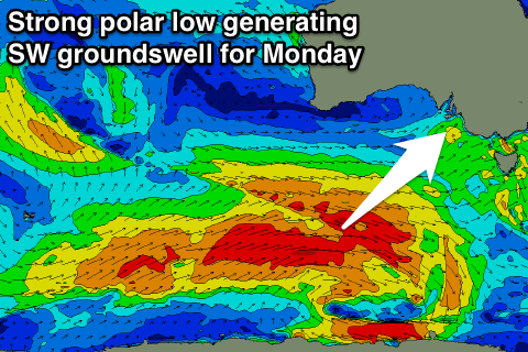
Early next week is looking great with some strong new SW groundswell for Monday from another strong polar low firing up south-west of WA Friday and pushing east over the weekend.
A pre-frontal fetch of W/NW gales will be closely followed by slow moving post-frontal W/SW winds, generating a moderate to large sized SW groundswell for Monday. A secondary front piggy-backing up over the back and more north in latitude will generate a reinforcing W/SW groundswell for Tuesday. We'll have a closer look at this swells and winds on Friday.

