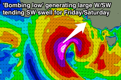
Large W/SW tending SW swell developing from 'bombing low'
South Australian Forecast by Craig Brokensha (issued Wednesday 17th August)
Best Days: South Coast Thursday morning, Mid Coast keen surfers Friday afternoon and Saturday, South Coast for experienced surfers Saturday, South Coast Sunday and Monday
Recap
Excellent waves across the South Coast yesterday from Middleton to Waits with a good strong but inconsistent swell and offshore winds. The Mid Coast offered 1-2ft sets but conditions were bumpy with with the N'ly wind.
This morning much better conditions were seen on the Mid with offshore E'ly winds and glassy 1-2ft sets. The South Coast was less than ideal with average conditions from overnight onshores, but is now improving with winds swinging more NE as expected.
This week and weekend (Aug 18 - 21)
A reinforcing pulse of W/SW groundswell due later this afternoon, peaking overnight was generated in our far swell window in the south-eastern Indian Ocean.
This should ease tomorrow from an inconsistent 1ft to occasionally 2ft on the Mid Coast, with 2-3ft sets off Middleton, smaller through the day.
Conditions will be best during the morning down the South Coast with a strengthening N'ly, tending N/NW into the afternoon and then backing off from the NW into the afternoon. A small junky NW windswell is due to develop across the Mid but to no major size.
Now, the outlook into Friday and Saturday has changed a little, with an intense low that was forecast to develop to our south-west and south, now due to develop more to our west.
 This will actually be a 'bombing low' as well, with it dropping more than 24hPa in 24 hours.
With this we'll see a fetch of severe-gale to storm-force (and possibly hurricane-force) W/SW to SW winds aimed through our western and then south-western swell windows as the low slowly tracks east-southeast.
This will generate a very large long-period W/SW tending SW groundswell event for us building Friday afternoon and easing through Saturday.
The Mid Coast will see the most size Friday afternoon, while the South Coast, Saturday morning.
The Mid should build to a strong 3ft+ through the day but with onshore W'ly tending W/SW winds.
The South Coast will see an early W/NW'ly but only be small and around 2ft+ across Middleton, becoming larger into the afternoon towards 3-5ft but with those W/SW winds.
Saturday morning looks great for experienced surfers with large 6-8ft waves off Middleton and larger sets at deep water offshore reefs and Waits and Parsons. Winds will swing back to the W/NW, favouring protected spots. The Mid will ease back from a bumpy 3ft or so.
Sunday will become more accessible for other surfers, with the swell easing while tending more S/SW, from the 4ft range at Middleton and 5-6ft at Waits and Parsons. Smaller 2ft sets are due on the Mid. NW tending N/NW winds will also create excellent conditions.
Into early next week, the surf will contine to ease under favourable offshore winds for the South Coast. Some tiny mid-period W/SW swell is due across the Mid Monday to 1-1.5ft+, fading through Tuesday.
Longer term some better W/SW swell is possible mid-late week, but more on this Friday.


Comments
Oh yeah!!
Craig that storm even projects a small sse swell as it gets near tassie . 170 degree @ 10-11 sec . Can you that ?happening ?
Yep, totally, arriving later Tuesday/Wednesday morning for your region.
Fuck thats rare..k.i block at all craig?
I reckon barley could be a few rare beaches receiving . And its due from west oz across to vic evenly spread
Woah, if it occurs, it will be a spin out..but no hopes up just novelty