Lots of W/SW swell to come with favourable windows of wind
South Australian Forecast by Craig Brokensha (issued Wednesday 10th August)
Best Days: South Coast every day over the coming period (less so Saturday morning), Mid Coast Thursday afternoon, Friday morning, Sunday, Monday morning
Recap
Poor conditions across the Mid Coast yesterday with increasing onshore winds and building levels of windswell into the afternoon. The South Coast was small and clean during the morning, best at exposed breaks with a swing to W'ly breezes into the afternoon as the swell kicked slightly.
Today solid choppy 3ft surf was seen across the Mid as a large W/SW groundswell filled in, and we should see this peak through the day to 3-4ft.
The South Coast was around 3ft this morning with cross-offshore winds, and we should see Middleton reaching 3-5ft this afternoon as winds continue to strengthen from the W/NW ahead of a mid-late afternoon W/SW change.
This week and weekend (Aug 11 - 14)
Today's increase in W/SW swell will be reinforced by a secondary pulse of mid-period and large W/SW swell tomorrow, produced by broad fetches of W/SW gales pushing through the Bight yesterday and today.
The Mid Coast should ease back from 3-4ft while the South Coast is expected to hang around 3-5ft most of the day at Middleton, larger out at Waits and Parsons.
Conditions are looking dicey early with a moderate to fresh W/SW breeze due at dawn across most locations, while a swing to a lighter W/NW and then NW is due from midday, creating much better conditions across both regions into the afternoon.
Friday looks excellent down South as the swell eases from 3-4ft at Middleton under moderate to fresh N/NW tending W/NW winds. The Mid is due to be back to a smaller 2ft with early N/NE winds.
 During Saturday we'll fall in between swells and winds aren't ideal with bumpy 1-2ft surf due across the Mid, with workable 2ft to sometimes 3ft sets at Middleton with a W'ly tending W/NW breeze.
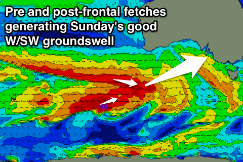
Into Sunday though another pulse of moderate to large W/SW groundswell is expected, generated by a couple of mid-latitude frontal systems.
Firstly a mid-latitude low will fire up south-west of WA this afternoon and project a fetch of W/SW gales towards us before weakening while nearing the Bight tomorrow night.
This will set in motion an active sea state for a stronger mid-latitude front to move over, with a pre-frontal fetch of W/NW gales being immediately followed by post-frontal W/SW gales.
A good W/SW groundswell should result, possibly showing later Saturday but peaking Sunday to a good 2-3ft on the Mid and 4-5ft at Middleton with 6ft to possibly 8ft sets at Waits and Parsons.
W/NW tending NW winds will favour the South Coast, but the Mid should become good through the afternoon as the NW winds lighten.
Into early next week the swell will ease with good conditions for both coasts under a N/NE tending N/NW breeze.
The rest of the week will consist of smaller pulses of W/SW groundswell from less than favourably aligned frontal systems, but more on this Friday.


Comments
A good day of waves ahead down South..