Large stormy swells, great from Thursday
South Australian Forecast by Craig Brokensha (issued Monday 11th July)
Best Days: Stormy Mid Coast waves tomorrow afternoon, keen surfers South Coast Tuesday morning, South Coast from Thursday
Recap
Great waves down South Saturday with a clean easing 2-3ft of swell off Middleton and great waves at Waits and Parsons. Sunday was tiny and not good at all. The Mid was tiny Saturday and effectively flat through Sunday.
Today though a large NW windswell has developed across the Mid Coast with damaging gale-force NW winds as a very strong mid-latitude low moves in from the west.
Winds are due to ease later, resulting in the windswell also backing off, while the South Coast is tiny and the swell too west to make any impact.
This week (Jul 12 - 15)
Early tomorrow we're likely to fall between swells, with the mid-latitude low weakening and moving further west, while the cold front proper moves in through the day.
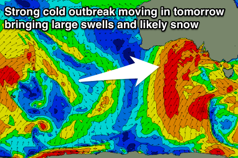
 This cold outbreak will be significant enough to bring snow to SA's higher peaks tomorrow afternoon and evening, with a large building W/SW groundswell due tomorrow from a fetch of gale to severe-gale W/SW winds pushing in from the Bight.
This will be then followed by a more elongated fetch of S/SW gales projecting up and into us tomorrow afternoon through Wednesday morning.
The Mid Coast is expected to build to a stormy 3-5ft through the afternoon again with gale-force W'ly tending W/SW winds.
The South Coast should build in line similar to our model forecasts with 3-5ft sets by dark at Middleton and 6ft+ waves at Waits and Parsons under gale-force W/NW tending W/SW winds. The morning will be smaller, and more so in spots handling the wind.
The South Coast will peak in size Wednesday, and our models are over-forecasting the size due to it not being able to separate the windswell and groundswell components.
Middleton should offer 6-8ft sets with larger 10ft waves at offshore reefs and Waits and Parsons, while the Mid Coast is expected to ease from 3-4ft.
Conditions will be poor though with a fresh to strong but easing SW'ly wind, with only a slim chance for an early W'ly around Victor.
The end of the week is looking excellent though with reinforcing pulses of strong S/SW groundswell across the South Coast Thursday and Friday morning's from secondary fetches of gale to severe-gale W/SW winds pushing into Tassie and Vicco.
Middleton should ease back slowly from 5-6ft Thursday morning and then 4-5ft Friday with larger surf at magnets and Waits and Parsons. The Mid will ease from a smaller 2ft or so.
Offshore W/NW-NW winds are expected most of the day Thursday and then Friday should see straight N'ly tending NW winds.
Into the weekend clean conditions will continue with N'ly winds and small fun levels of W/SW swell. Sunday looks biggest to 2-3ft at Middleton, but more on this Wednesday.

