Good swells with improving winds, large and stormy into next week
South Australian Forecast by Craig Brokensha (issued Wednesday 6th July June)
Best Days: Keen surfers South Coast tomorrow, South Coast Friday and Saturday, Stormy Mid Coast waves from Sunday through Tuesday, South Coast Wednesday
Recap
Cleaner conditions across the Mid Coast yesterday with a S/SW wind and 2ft of swell. The South Coast was a large stormy mess with no options for a decent wave.
Today terrible conditions continued down South with strong S/SE winds, while the Mid was easing back from a lumpy 1-1.5ft.
This week and weekend (Jul 7 - 10)
Conditions will improve through the end of the week and into the weekend as the low responsible for our current poor weather moves off further to the east.
Today's windswell will fade away down South, replaced by a stronger SW groundswell tomorrow morning. This will be a mix of long-range and inconsistent SW groundswell and slightly more consistent S/SW energy.
Middleton should see good 3-4ft waves with larger sets at Waits and Parsons, while a secondary pulse of reinforcing S/SW groundswell Friday will keep 3ft+ sets hitting Middleton during the morning, easing slightly into the afternoon. This is a bit under model forecasts, with the wave model looking to have over-forecast the size of the coming swells.
The Mid Coast isn't expected to offer much size with 1-1.5ft sets on the favourable parts of the tide tomorrow if we're lucky, fading back Friday.
 Conditions will improve through the morning tomorrow as a dawn and light E/SE'ly tends more NE and then back to a more variable S/SE'ly into the afternoon. Friday then looks great with a light offshore N'ly ahead of a very light afternoon sea breeze (likely variable).
Into the weekend we should see the S/SW swell easing back from 2-3ft at Middleton and 3-4ft at Waits and Parsons under fresh and gusty N/NE tending NE winds. Sunday won't be too flash with the new W/SW swell due now wiped off the cards while strong N/NW winds will blow out the surf. This strong NW'ly will kick up a stormy increase in windswell across the Mid Coast though, likely reaching 3-4ft.
Next week onwards (Jul 11 onwards)
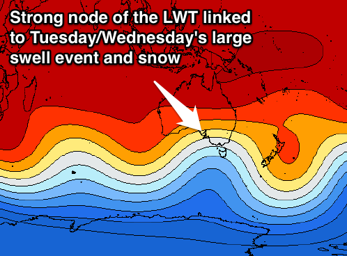
The developments on Sunday will be linked to a strong and powerful cold outbreak occurring over the south-east of the country, owing to a strengthening node of the Long Wave Trough.
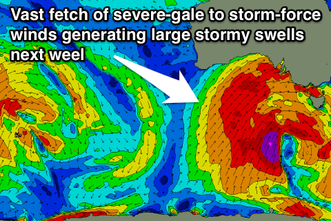
This node will move in from the west during the weekend and strengthen through the Bight, resulting in the formation of a broad and intense mid-latitude low through the Bight, extending all the way over to Western Australia.
 This low will then draw and in and link up with a vigorous polar frontal system and move slowly east as the LWT also slides slowly east while strengthening further.
What will result is a series of large stormy W/SW swells for the Mid from Sunday through Tuesday, while the South Coast will see building W/SW swell energy Monday ahead of a large S/SW groundswell event Tuesday and Wednesday.
Size wise the Mid looks to see easy 3-4ft waves through this period, likely larger Tuesday morning and to 5ft.
The South Coast will become very large with sets in the stormy 8ft+ range way off Middleton with 10ft+ surf off Waits and Parsons with strong W/SW-SW winds.
Wednesday morning will likely see winds tend W/NW down South as the large S/SW groundswell starts to ease from the 8ft range but more on this Friday.

