Good solid clean surf over the coming days, large W/SW swell next Tuesday
South Australian Forecast by Craig Brokensha (issued Wednesday 11th May)
Best Days: South Coast Thursday through Sunday morning, and then Monday morning, Tuesday
Recap
Monday afternoon's large and damaging stormy swell across the Mid Coast eased back in intensity through Tuesday with stormy easing 3ft waves along with a gusty but easing onshore wind.
The South Coast remained a mess but offered solid waves with SW winds.
This morning things settled down further on the Mid back to 2ft as moderate to fresh onshores continued. The South Coast was cleaner and good in protected spots with stronger levels of groundswell offering 4-5ft sets around town.
This week and weekend (May 12 - 15)
South Coast: Today's SW groundswell across the South Coast will ease back through tomorrow, only to be replaced by a new SW groundswell through the day and then S/SW pulse for Friday morning.
This will be linked to a drawn out frontal system currently to our south-west. A fetch of severe-gale to sub-storm-force SW winds on the frontal systems tail is being projected towards, with severe-gale W/SW winds at its head, moving in through this afternoon and evening.
An initial SW groundswell is due tomorrow, keeping 4-5ft sets hitting Middleton, with the S/SW energy arriving later in the day, peaking overnight and easing Friday.
Larger 4-6ft waves are due later Thursday across Middleton, easing back from 4-5ft+ Friday morning. The swell should ease further into Saturday from a good 3ft+ across the Middleton stretch with larger 4-5ft sets at Waits and Parsons. Sunday will then be smaller again, ahead of a late increase in new swell, discussed below.
Conditions over the coming period will be great for the South Coast, best Friday and Saturday with a fresh W/NW'ly tomorrow, moderate to fresh N/NW winds Friday and Saturday, then W/NW tending weaker W/SW winds Sunday.
Mid Coast: The coming swells for tomorrow and Friday will be less than favourably aligned for the Mid, with bumpy 2ft waves through tomorrow, easing back to a small 1-2ft Friday. Saturday isn't due to see any major size with leftover 1ft+ sets and then similar into Sunday.
Next week onwards (May 16 onwards)
Later in the day Sunday we may see some long-range and inconsistent W/SW groundswell across the state, but this will be more noticeable through Monday.
The source of this swell is a vigorous polar frontal progression that formed west of Heard Island yesterday aligned poorly in our swell window.
This progression is moving further east more favourably into our swell window while generating a better and slow moving fetch of gale to severe-gale W/SW winds.
 The swell should fill in overnight Sunday and peak Monday to a strong but inconsistent 3-4ft+ across Middleton and 5-6ft at Waits and Parsons. The Mid Coast should see good but inconsistent sets to 2ft+. Fresh N/NW winds ahead of a W/SW change will favour the South Coast again.
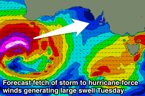
Of greater significance is the development of a very intense mid-latitude low west-southwest of WA, projecting a fetch of storm to possibly hurricane-force W/SW winds directly under WA and towards the Bight.
A large long-period W/SW groundswell will result, filling in Tuesday and reaching a strong 3-4ft across the Mid Coast, with Middleton building to 4-6ft with larger 8ft sets at Waits and Parsons. W/NW winds will continue to favour the South Coast, but we'll review this again Friday.


Comments
Lock Friday in captain.