Improving surf tomorrow down South, good and easing Sunday, stormy next week
South Australian Forecast by Craig Brokensha (issued Friday 6th May)
Best Days: Later Saturday South Coast, all day Mid Coast, Sunday South Coast
Recap
Excellent waves down South with clean pumping surf between 4-6ft at most spots around Victor, while the Mid Coast was cleaner but more around 2ft+.
This morning the swell has continued to ease with a more variable but light offshore wind down South and clean 1-2ft waves on the Mid Coast.
This weekend and next week (May 7 - 13)
South Coast: The weekend will continue to provide plenty of surf, with a frontal system that's currently passing under us generating a good W/SW tending SW swell for tomorrow.
We should see Middleton continue around the 4ft range with 5-6ft sets at Waits and Parsons, easing slowly Sunday from 3-4ft and 5ft+ respectively.
Conditions will improve through the afternoon Saturday and be less than ideal early as a deepening mid-latitude low forms to our west.
Morning E/NE winds are due to swing more NE through the afternoon and freshen, so there's no need to aim for a morning surf, as the mid-late afternoon will be best.
Sunday then see the low starting to move east, bringing fresh and and gusty but easing N'ly tending N/NW winds.
Monday will be small and average with a strong N'ly tending W'ly wind, likely blowing out the surf.
The mid-latitude low will move across us Monday evening, aiming a fetch of strong to gale-force S/SW winds into the South Coast.
A stormy short-range SW swell is expected to develop Tuesday, coming in at 4-5ft at Middleton and 6ft+ at Waits and Parsons but with gusty W/SW winds.
A secondary strong frontal system will move in quickly behind the mid-latitude low, projecting a fetch of gale to severe-gal SW winds through our southern swell window Tuesday and Wednesday.
This should produce a larger stronger S/SW groundswell for Thursday to 6-8ft across Middleton and other exposed spots with larger sets at Waits and Parsons. Fresh to strong SW winds look to keep conditions poor though. We'll review this Monday though.
 Mid Coast: The W/SW swell tomorrow should build to a good 2ft+ across the Mid through the day before easing back from 2ft Sunday morning.
Conditions should be clean most of tomorrow with increasing E/NE winds, while Sunday will be average with the N'ly winds.
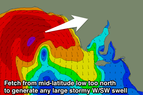
The intense mid-latitude low will unfortunately just stay a bit too north to generate any large stormy swell across the coast Monday, with only a weaker increase in NW tending SW windswell due to 2ft+ all day, easing from 2ft Tuesday.
The secondary front will be stronger but less favourably aligned with surf to 2ft due again Wednesday afternoon and Thursday but with poor conditions. We'll take another look at this Monday. Have a great weekend!


Comments
Good sets with the tide across the Mid this afternoon.
A beautiful satellite image of the intense mid-latitude low last night to our west.
Hows the infeed and wrap around .
Insane, that polar air being advected north on the backside of the low.