Fun across exposed breaks all week, prolonged swell event developing next week
South Australian Forecast by Craig Brokensha (issued Monday 25th April)
Best Days: Swell magnets on the South Coast every day this week, Mid Coast Wednesdy afternoon and Thursday
Recap
Average but workable waves Saturday with a building swell and E'ly breeze while yesterday was much better as winds swung offshore with fun amounts of swell from Middleton to Waits and Parsons. The Mid saw tiny waves all weekend ideal for beginners.
This morning the swell was small and easing, best at swell magnets on the South Coast.
This week (Apr 26 - 29)
South Coast: It's a week for the swell magnets with no significant swell due across the South Coast but good conditions under warm and persistent N'ly winds.
Tomorrow morning a small and inconsistent SW groundswell should keep 2ft+ waves hitting Middleton with 3-4ft sets at Waits and Parsons through the morning, easing into the afternoon. Conditions will be clean and good all day with a N/NE offshore, tending variable into the afternoon.
Into Wednesday a mix of W'ly swells are due, the best one being generated by a weakening mid-latitude dipping south-east under Western Australia.
This low is producing a fetch of W/SW gales through our western swell window and will produce more meaningful waves for the Mid, but Middleton should kick to 2ft+ through the day with 3-4ft sets at Waits and Parsons again under N/NW tending NW winds.
A late/evening and shallow W/SW change is due, and this will result in winds tending more variable into Thursday morning and most of the day as the W/SW swell starts to ease from 2ft and 3ft to occasionally 4ft respectively.
Friday will then be small to tiny with fresh and gusty N/NW tending variable winds.
Mid Coast: The structure of the mid-latitude low and following fronts isn't as favourable as forecast on Friday and we're looking at less size during the peak of the swells produced off this system.
A late long-period kick may be seen tomorrow evening, to 1-1.5ft, but a better W/SW pulse is due Wednesday from the fetch under WA, providing good 2ft sets as winds tend variable, easing back from 1-2ft Thursday further into Friday, but not below 1ft.
This weekend onwards (Apr 30 onwards)
Saturday is expected to remain small across both coasts with pre-frontal NW-W/NW winds.
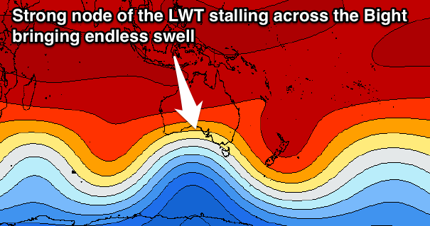
 From Sunday we'll move into a pro-longed period of swell activity as a strengthening node of the Long Wave Trough moves into the Bight and stalls.
This will project front after front after front up through our western swell window.
We're looking at over a week of waves across the Mid Coast with good fun waves down South, cleaner under the prevailing westerly winds. Check back here Wednesday for more idea on the timing and sizes of swell pulses.

