Easing but improving surf from Sunday with good westerly swell next week
South Australian Forecast by Craig Brokensha (issued Friday 22nd April)
Best Days: Sunday morning South Coast, Monday through Thursday morning South Coast, Mid Coast Wednesday morning and Thursday
Recap
Onshore tiny 1ft waves yesterday on the Mid with a nice fun clean morning of small waves down South before an onshore change moved in mid-morning.
Today the South Coast was a small junky mess with a strong onshore and messy windswell, while the Mid saw cleaner tiny 1ft sets.
This weekend and next week (Apr 23 - 29)
South Coast: There's been no real change to the weekend's mix of swells, but keep in mind the forecast model is over-forecasting the size.
What we should see is an initial SW groundswell pulse tomorrow morning ahead of a stronger increase into the afternoon, peaking overnight and then ease back steadily through Sunday and Monday.
Middleton should build to 3ft on the sets into the afternoon with 4-5ft sets at Waits and Parsons, easing from a similar size Sunday morning.
Conditions are still looking average tomorrow with a moderate SE to possibly E/SE breeze, freshening from the S/SE through the afternoon.
Sunday looks cleaner but probably still a little peaky with a NE offshore ahead of SE sea breezes.
Into Monday the surf will be really straight under a N'ly tending variable wind but the swell small and easing from 2ft at Middleton and 3-4ft at Waits and Parsons.
Into Tuesday a new S/SW groundswell is due across the South Coast, produced by a short-lived but strong polar firing up south of WA on the weekend.
This should kick Middleton back to a fun 2-3ft, with 3-4ft+ sets at Waits and Parsons under fresher but easing N/NE winds.
The W/SW and SW swells mentioned last update have now changed.
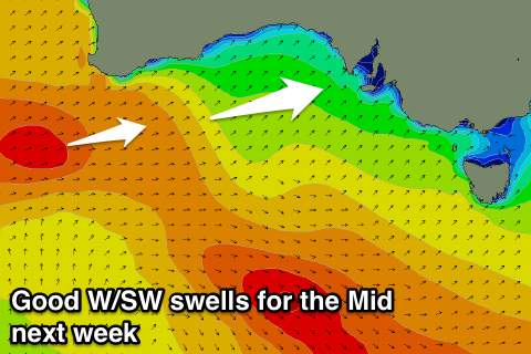
What we'll see is an initial intense mid-latitude low producing a tight fetch of severe-gale to storm-force W/SW winds just in the Mid's swell window, before a secondary system produces a better fetch of W/SW gales through its swell window, followed by then a a final fetch of SW gales wrapping around the tail of the progression.
The first W/SW swells will hardly impact the South Coast through later Tuesday and Wednesday morning, but some better size is due into the afternoon and more so Thursday.
 At this stage Wednesday will remain clean with a fresh and gusty N'ly tending NW breeze, while Thursday may see a morning W/NW'ly but we'll review this Monday.
Mid Coast: The weekend isn't too interesting with maybe 0.5-1ft sets into Saturday, but the W/SW groundswell pulses are much better.
The first due later Tuesday may kick to 1-1.5ft by dark, but Wednesday should provide more size with 2ft sets, the largest pulse Thursday morning to 2-3ft. We'll review this again Monday though. Have a great weekend!

