Nothing special to end the week, better from Sunday
South Australian Forecast by Craig Brokensha (issued Wednesday 20th April)
Best Days:
Recap
Super clean and fun waves across the South Coast yesterday around 2ft+ off Middleton and better to 3-4ft at Waits and Parsons with morning offshore winds, ahead of weak afternoon sea breezes.
Today the swell is even smaller but clean and straight again with 1-2ft sets off Middleton and better options at Waits and Parsons. The Mid Coast offered tiny 0.5ft waves yesterday but is effectively flat today.
This week and weekend (Apr 21 - 24)
South Coast: A very inconsistent long-range SW groundswell is due to peak tomorrow morning but I feel the models are overcooking the size a little.
We're only probably due to see sets to 2ft+ across Middleton and 3-4ft waves at Waits and Parsons, easing through the day. The window for clean conditions is small and flukey, with a variable W'ly breeze due early tomorrow morning ahead of a fresh S/SE change mid-morning.
Friday will then be a write-off with small to tiny leftovers and a gusty S/SE breeze.
Into the weekend a series of new SW and S/SW groundswells are due.
The least important is a very inconsistent long-period and long-range SW groundswell from the southern Indian Ocean due to build Saturday peaking into the evening.
Two closer-range sources will provide more size and consistency than this swell though, the first generated by the remnants of the storm linked to the long-period swell, producing a fetch of strong to gale-force W/SW winds through our swell window today and early tomorrow morning.
This system will then be followed by a later forming and now weak secondary system resulting in a downgrade in the size due through the weekend.
The models are over-forecasting the whole weekend and I'm only expecting Middleton to maybe reach 3ft Saturday with 4-5ft sets at Waits and Parsons, easing back from a similar size Sunday morning.
Now, conditions Saturday will be average with a moderate E/SE'ly ahead of S/SE sea breezes, while Sunday looks better with a N/NE morning offshore ahead of S/SE sea breezes.
Mid Coast: No real decent size is due across the Mid at all into the end of the week or weekend, with near flat conditions tomorrow and Friday, lifting a touch to 0.5ft to maybe 1ft Saturday.
Next week onwards (Apr 25 onwards)
The weekend's swell will continue to ease into early next week with small fun and clean waves across the South Coast under N'ly winds Monday.
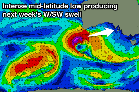
 Into Tuesday afternoon and Wednesday morning though a new pulse of good W/SW groundswell is due, generated by an intense mid-latitude low forming south-west of WA, tracking east while generating a tight fetch of severe-gale to storm-force W'ly winds.
The low will then drift south-east while moving south of the Bight early next week while continuing to generate storm-force winds, producing a better aligned SW groundswell for the South Coast.
What we can expect is a strong W/SW groundswell for the Mid Coast on Tuesday afternoon, reaching 2-3ft by dark and then easing from a similar size Wednesday.
The South Coast should kick later Tuesday with the W/SW swell but only to 2-3ft at Middleton and 4ft at Waits and Parsons. Wednesday looks better with sets to 3-4ft and 4-5ft respectively but more on this Friday.
Beyond this there's plenty more activity, but have a check back at the next update Friday.

