Clean easing surf, average end to the week, fun Sunday
South Australian Forecast by Craig Brokensha (issued Monday 18th April)
Best Days: Tuesday, Wednesday morning swell magnets, dawn Thursday swell magnets, Sunday, Monday
Recap
Average start to the weekend with a small onshore swell across the South Coast and tiny waves on the Mid.
Into yesterday a strong S/SW groundswell started to kick across the coast with sets in the 3-4ft range through the morning under an OK E'ly breeze, kicking much larger and stronger into the afternoon but with gusty S/SW winds.
The Mid saw fun 1-1.5ft sets, but come today the surf was back to a tiny 0.5ft. The South Coast saw improving conditions under an all morning offshore with plenty of size in the mix to 3-5ft.
This week (Apr 19 - 22)
South Coast: Since yesterday's strong kick in S/SW groundswell, the Cape du Couedic wave buoy has been on a steady decline and we'll see this occur across the South Coast this afternoon, overnight and further through tomorrow with the swell bottoming out into the afternoon and Wednesday.
Conditions will be great with a N/NE offshore tomorrow morning, tending variable early afternoon ahead of weak afternoon sea breezes.
Middleton should ease from 2-3ft, with 3-4ft sets at Waits and Parsons, smaller into the afternoon with tiny 1-1.5ft leftovers Wednesday morning, 2ft+ at Waits and Parsons. Wednesday should be clean again with a morning N'ly ahead of a shallow SW change through the day.
Into Thursday a very inconsistent and small long-range SW groundswell is due. This should kick Middleton back to a very infrequent 2ft, with 3ft+ sets at Waits and Parsons, but you'll have to surf early as a morning NW'ly will give way to a gusty S'ly change mid-late morning, with smaller surf and fresh S/SE winds Friday.
Mid Coast: Nothing significant is due across the Mid this week, with tiny fading 0.5ft surf tomorrow, effectively flat through the rest of the week.
This weekend onwards (Apr 23 onwards)
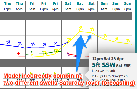
 South Coast: Into the weekend a mix of very inconsistent long-range SW groundswell and closer-range S/SW swell is due across the South Coast.
The long-range energy is being produced around Heard Island by a strong but weakening polar frontal progression. The swell off this is due to build Saturday and peak later int the day but not above a very very inconsistent 2-3ft at Middleton and 4ft+ at Waits and Parsons.
The shorter-range energy will be produced as the weakened polar front continues east, producing strong to gale-force W/SW winds and then restrengthens south of us early Thursday evening.
A more consistent and slightly bigger S/SW swell is due, filling in Saturday and peaking into the afternoon to a better 3ft+ across Middleton and 4-5ft at Waits and Parsons. Note that our model is combining the building long-range energy with the short-range swell and over-forecasting the size through Saturday afternoon and evening. The Mid isn't looking at any major size from this.
Both swells should drop through Sunday and further into Monday.
Now winds Saturday will be OK and from the E/NE, but Sunday is the pick with N/NE offshores, variable into the afternoon. Check back here Wednesday for confirmation on this.

