Best Thursday and Friday morning
South Australian Forecast by Craig Brokensha (issued Monday 11th April)
Best Days: South Coast Wednesday morning, Thursday, Friday morning
Recap
Good clean fun waves Saturday morning with the first pulse of SW groundswell, while into the afternoon the stronger long-period energy filled in with solids sets across the coast with workable S/SW winds.
The swell hung in swell Sunday morning, and increasing W/NW winds favoured protected breaks ahead of a late morning onshore change.
The Mid started tiny Saturday morning, but offered some small sets into the afternoon, before easing back from a choppy 1ft Sunday morning.
Today another pulse of strong S/SW groundswell is filling in across the South Coast with plenty of size but average onshore winds. The Mid was cleaner but tiny with the southerly aspect of the swell.
This week (Apr 12 - 15)
South Coast: Today's kick in S/SW groundswell will hold well into tomorrow morning but start to ease along with poor onshore S/SE winds.
Middleton should ease from 3-5ft, with larger sets at Waits and Parsons, smaller into Wednesday with easing 3ft waves at Middleton and conditions should be better with a morning E/NE wind ahead of S/SE breezes.
Thursday's new long-period SW groundswell is still on track, but the size has been downgraded a touch, with the vigorous polar low generating it only producing winds in the severe-gale range instead of storm-force.
The swell is expected to peak Thursday morning to an inconsistent but good 3ft+ across Middleton and 4-5ft at Waits and Parsons, with offshore N/NE tending N/NW winds and weak afternoon sea breezes.
Friday will be clean again through the morning ahead of a shallow onshore change, with easing 2-3ft sets at Middleton and 4ft waves at Waits and Parsons.
Mid Coast: The S/SW swell will ease back off from 0.5-1ft tomorrow morning, further into Wednesday, while the new S/SW groundswell for Thursday again doesn't look to top 0.5ft.
This weekend onwards (Apr 16 onwards)
 A low point in swell is due through Saturday morning and besides a possible light variable wind at dawn, a fresh S'ly change will move through, kicking up a poor quality windswell across the South Coast but not the Mid. The Mid however may see a small spike in W/SW swell from a small mid-latitude low passing under WA Wednesday evening. Expect tiny 1ft waves.
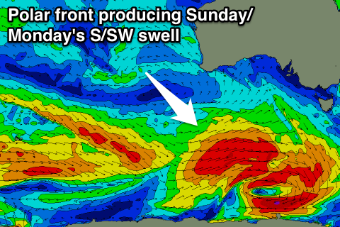
A good new S/SW groundswell is due into Sunday, peaking through the evening. This will be generated by a healthy and pro-longed polar frontal system developing south-east of Heard Island and tracking east under the country through the second half of this week.
Middleton is expected to reach 3-5ft, easing from a similar size Monday morning, with 1ft sets on the Mid, but gusty S/SE winds Sunday and SE winds Monday will create poor conditions.
We'll have another look at this Wednesday.

