Great Saturday and Sunday morning, average early next week
South Australian Forecast by Craig Brokensha (issued Friday 8th April)
Best Days: Saturday and Sunday morning South Coast, Monday morning Mid, Wednesday morning keen surfers South Coast, Thursday South Coast
Recap
Pumping waves across the South Coast yesterday and this morning with a slowly easing but decent sized S/SW swell along with morning offshore winds, more variable into yesterday afternoon.
The Mid Coast was a fun and glassy 1ft to occasionally 2ft yesterday morning, but back to a tiny 1ft+ this morning.
This weekend and next week (Apr 9 - 15)
South Coast: Our two pulses of S/SW groundswell for tomorrow are still on track, but the secondary pulse for the afternoon is due to be just a touch under expectations on Wednesday.
This is a result of the secondary front moving over the back of the original system not being quite as strong or expansive as forecast by the models earlier in the week.
So, tomorrow morning should start out with good 3-4ft sets across Middleton, 5ft at Waits and Parsons under offshore N/NW winds, creating great conditions.
The larger pulse is due to arrive around midday, kicking to a stronger 3-5ft and 6ft respectively into the afternoon. Winds will swing more W/NW into the afternoon ahead of a shallow W/SW change mid-late afternoon, but Middleton and other protected breaks should remain good.
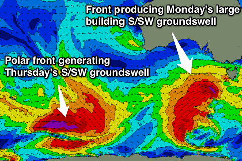
A slight drop in swell is due early Sunday morning, with a W/NW offshore, but a secondary flurry of vigorous polar frontal activity will generate a reinforcing SW groundswell for Sunday afternoon/evening ahead of a larger S/SW groundswell pulse Monday.
 A initial pre and post-frontal fetch of gales should produce Sunday afternoon's SW groundswell, with a stronger polar front projecting severe-gale SW winds up towards Victoria Sunday, through our southern swell window.
Middleton should build from 4-5ft Monday morning to a larger 6ft into the afternoon, with 6-8ft sets at Waits and Parsons.
Unfortunately winds will be poor and onshore following an afternoon SW change Sunday afternoon, persisting from the SW tending S'th Monday. There is a very slim chance for an early W'ly around Victor, but keep your expectations low.
The S/SW swell will remain strong into Tuesday but easing back slowly, with weaker S/SW winds.
A low point in swell activity is due Wednesday with less than ideal but workable E'ly winds.
Of greater importance is a strong new S/SW groundswell due Thursday morning along with offshore N/NE winds. This will be generated by a vigorous polar low being directed south-east from the Indian Ocean, into the polar shelf. A fetch of severe-gale to storm-force NW tending W/NW winds will be aimed along the Great Circle Path leading up towards us, resulting in a moderate sized S/SW swell.
We'll have a closer look at the specifics surrounding this swell on Monday though.
Mid Coast: Through tomorrow we should see an afternoon increase in surfable swell, reaching 1-2ft with the favourable push of the tide. Weak onshore W/SW winds should create workable conditions for keen surfers. Sunday then looks to offer smaller 1-1.5ft waves, with the odd 2ft set likely into the evening but with onshore winds.
Monday is looking better for a touch more size around 1-2ft, with Ok S'ly tending S/SW winds, easing back into the middle of the week. Have a great weekend!

