Great period ahead for the South Coast
South Australian Forecast (issued Wednesday 6th April)
Best Days: Thursday, Friday, Saturday and Sunday morning South Coast, Mid Coast Thursday morning, later Saturday and Monday
Recap
Excellent waves across the South Coast yesterday morning with a good sized and easing swell under morning offshore winds. The Mid Coast still provided 1-1.5ft sets but conditions were average with the N'ly breeze.
Today onshore winds are spoiling a new mix of swells across the South Coast, while the Mid was a glassy lumpy 1ft to sometimes 2ft this morning, but onshores kicked in mid-morning. A peak in W/SW swell is due this afternoon across the Mid with better 2ft+ sets due, but keep an eye on the South Port cam.
This week and weekend (Apr 7 - 10)
South Coast: Today's mix of W/SW and SW swell should ease back through tomorrow and bottom out through Friday.
Cape du Couedic looks like it's peaking and we'll see Middleton dropping back from the 3-4ft range tomorrow morning, with 5ft sets at Waits and Parsons under a better light offshore W/NW wind around Victor Harbor, tending only weak W/SW into the afternoon.
Friday when the swell bottoms out should still continue to see 2ft+ waves at Middleton and 3-4ft waves at Waits and Parsons with a light NW offshore and weak SW sea breezes again.
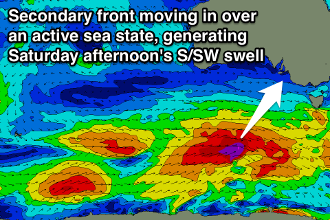
 Into the weekend, our strong pulses of S/SW groundswell are still on track for Saturday, with back to back polar fronts developing tomorrow and Friday. The first front will produce a broad and elongated fetch of severe-gale W/SW winds, quickly overridden by a secondary slightly stronger system.
Two separate pulses of S/SW groundswell are due, the first for Saturday morning, ahead of a stronger pulse through the middle of the day/afternoon.
Middleton should build towards 3-5ft Saturday afternoon, with 6ft sets at Waits and Parsons, easing from 3-4ft and 4-6ft Sunday morning.
Conditions are looking great Saturday with an offshore N/NW tending W/NW breeze into the afternoon, ahead of a late afternoon W/SW change.
Sunday will be best in protected locations with a moderate to fresh W/NW breeze during the morning, swinging W/SW into the afternoon.
Mid Coast: This afternoon's increase in swell hopefully to 2ft+ is due to ease back tomorrow morning with cleaner conditions under a variable breeze (likely SE). There should still be 2ft sets on offer, fading through the day.
The weekend's S/SW groundswell won't be favourable for the Mid with, Saturday afternoon still likely to reach 1-2ft, fading back from 1-1.5ft Sunday morning.
Of greater importance is secondary similar strength but further north protruding polar frontal activity into the weekend. This should generate some better size on the Mid into Monday around 2ft, easing back through Tuesday and Wednesday.
The South Coast will see some solid swell from this progression but onshore S'ly winds will create average conditions.

