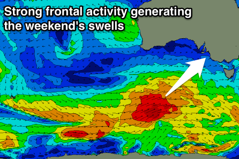
Good period for the South Coast
South Australian Forecast (issued Monday 4th April)
Best Days: Tuesday morning down South, Thursday morning onwards down South until Sunday, Mid Coast Thursday morning and Saturday for keen surfers
Recap
An average start to the weekend with onshore winds and plenty of building swell across the South Coast, while the Mid Coast was small and onshore ahead of a strong afternoon kick in size to 2-3ft as winds tended offshore late.
Sunday was the pick across both coasts with light offshore winds, pumping 2-3ft waves on the Mid and large 6ft+ surf down South with larger 8ft bombs at offshore reefs and Waits and Parsons.
This morning the surf was good again across both coasts with easing 1-2ft waves on the Mid and a more lumpy and peaky but improving 3-5ft down South with a E/NE tending NE breeze.
This week (Apr 5 - 8)
South Coast: The Cape du Couedic wave buoy has been on a steady decline since the weekend, and we'll continue to see the surf easing into tomorrow with offshore winds N/NW winds early, swinging W/NW late morning ahead of an afternoon SW change. Therefore get out through the morning with easing 3ft sets at Middleton and bigger bombs at Waits and Parsons.
Into Wednesday a new mix of W/SW and SW swell are due from a strengthening front/low moving in from the west over the coming days.
A fetch of SW gales will be aimed under WA through our western swell window this afternoon before the system moves east and continues towards us, generating a stronger SW fetch through our south-western swell window.
Both W/SW and SW swells should arrive around the same time and peak through Wednesday afternoon to 3-5ft across Middleton and 4-6ft at Waits and Parsons. Unfortunately winds will be onshore with the swell producing low passing by us resulting in fresh but easing SW winds.
Thursday is the day with the swell due to ease back from 3-4ft at Middleton and 4-5ft at Waits and Parsons under a light morning NW wind, swinging onshore during the day.
Friday will be the bottom of the swell cycle, but a morning W/NW wind should create clean conditions again.
Mid Coast: Tiny surf is due into tomorrow around 1ft but the W/SW swell for Wednesday should build to to a good 2ft+ through the day, but with those onshore winds. Thursday may be cleaner with a more variable breeze and easing 2ft wave.
This weekend onwards (Apr 9 onwards)
 South Coast: From the middle of this week through the weekend and early next week we'll see a procession of strong but not overly significant polar fronts through our southern and south-western swell windows as a strong node of the Long Wave Trough stalls across Tasmania.
With the back to back frontal activity we'll see back to back moderate pulses of S/SW groundswell from this Saturday through most of next week.
The first pulses for the weekend look the best at this stage, with Saturday seeing two separate swells, peaking into the afternoon/evening to 3-5ft at Middleton and 6ft+ at Waits and Parsons.
Conditions are looking good again down South with a light morning NW breeze, swinging W/SW into the afternoon, with less favourable W/SW tending SW winds Sunday as the swell starts to ease back.
The additional pulses of swell for next week look to be with average onshore S'ly winds, but we'll confirm this Wednesday.
Mid Coast: The swells won't be ideally aimed for the Mid, but the constant activity should still see surf to 1-2ft from Saturday through likely Monday with improving winds.

