Improving down South, best Thursday
South Australian Forecast (issued Monday 20th April)
Best Days: Wednesday morning down South, Thursday down South, Friday morning in protected spots down South
Recap
Onshore and average 2ft waves across the Mid Saturday with clean and good surf across the South Coast before an onshore change moved through late afternoon.
Into Sunday a large and powerful SW groundswell offer solid but poor waves down South with a fresh onshore wind, while the Mid Coast was cleaner with a cross-shore S/SE'ly and 2ft to occasionally 3ft waves across swell magnets (a little under the expected 3ft+).
Today the swell was easing but much cleaner on the Mid with 2ft sets, while the Surf Coast continued to offer plenty of size but less than ideal conditions.
 This week and weekend (Apr 20 – 24)
The surf will continue to ease over the coming days and bottom out early Thursday.
Winds will remain good for the Mid, but only a tiny 1ft+ wave is due into tomorrow, while the South Coast will be OK but far from perfect with an E/SE'ly tomorrow morning and better E/NE winds Wednesday morning.
Size wise Middleton should ease from 3ft tomorrow with 4ft+ sets at Waits and Parsons, dropping further from 2ft to occasionally 3ft Wednesday morning at Middleton and 3-4ft at Waits.
Into Thursday a strong new SW groundswell should build, generated by a strong polar frontal system firing up to the south-west of WA today.
This frontal system will push east-southeast while generating a fetch of severe-gale W'ly winds in our swell window, which isn't ideal but due to the broad and strong nature of the system, we should still see moderate amounts of swell for our region.
The swell is due to arrive mid-morning down South and build to 3-5ft at Middleton and 5-6ft at Waits during the afternoon with tiny 1ft waves on the Mid.
Winds look great with an offshore N/NE tending variable breezes down South creating a full fun day of waves.
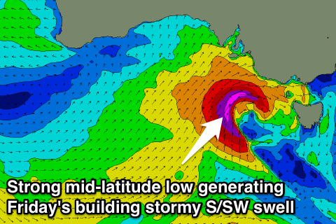
Into Friday the swell will start to ease, but this will be countered by a large increase in short-range S/SW swell from a deepening mid-latitude low moving in from the west, aiming a fetch of severe-gale to storm-force S/SW winds into us.
The South Coast is due to build to a large and stormy 6-8ft Friday afternoon but with strong onshore W/SW winds. The Mid should kick to a stormy 2-3ft. The morning will be workable in protected locations like Middleton Bay with a strong W/NW offshore.
Come Saturday the swell is expected to ease from a large 6ft+ or so but with poor and strong S/SW winds. The Mid will also be average and easing from the 2ft+ range.
Sunday doesn't look any better as SW winds persist, with only a slight chance of an early W'ly around Victor at dawn. Into early next week, another weaker front pushing up into us Sunday will continue to provide plenty of size down South but with onshore S/SW winds, but we'll review this again Wednesday.

