Fun tomorrow morning, good weekend
South Australian Forecast (issued Wednesday 18th February)
Best Days: Thursday morning down South, later Friday on the Mid for tiny peelers, Saturday and Sunday mornings down South, Tuesday on the Mid
Recap
Monday's good pulse of W/SW groundswell across the Mid held in better than expected Tuesday with 2ft sets still pushing through under offshore winds. Even today there was the odd 1-1.5ft set at swell magnets.
The South Coast offered plenty of size but poor conditions with onshore winds both yesterday and this morning.
This week and weekend (Feb 19 - 22)
Today's strengthening S/SE winds across the South Coast will kick up a junky S/SE windswell that should ease back through tomorrow morning from 2-3ft across most locations.
A new very inconsistent SW groundswell is due to fill in during the morning though, offering better straighter lines of groundswell to 3ft on the sets at Middleton and 4ft+ at Waits and Parsons, while the Mid should see tiny 1ft peelers.
Winds will improve and tend around to the E/NE during the morning, with even periods of NE breezes likely at times. This will favour protected points and corners over more exposed spots like Middleton which will be quite unorganised still.
The swell is due to drop back into Friday morning as winds turn back for the worse, blowing from the SE to S/SE.
Into the afternoon though we should see a strong new SW groundswell fill in, generated by a strong polar low firing up further east than the last system, currently generating a fetch of gale to severe-gale W/SW winds through our swell window. The low will weaken through today leaving the SW groundswell to arrive through Friday, building to 1ft+ on the Mid Coast later in the day with 3-4ft sets at Middleton and 4-5ft waves at Waits.
While the swell will drop slowly through the weekend, conditions will improve dramatically with an offshore N'ly breeze Saturday morning and variable tending light offshore winds Sunday morning.
Saturday morning will be the pick for experienced surfers though at exposed beaches with the most size and cleanest conditions. The Mid should ease from a tiny 1ft or so.
 Next Monday onwards (Deb 23 onwards)
As touched on last update, a strengthening node (peak) of the Long Wave Trough is forecast to move in from the west later this week, reaching a peak in intensity as it stalls over the Bight on Sunday evening.
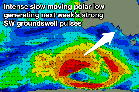
With this development we'll see a vigorous polar low developing south-west of WA in a similar position to the system generating later Friday's swell, with the low expected to stall, aiming a persistent and broad fetch of gale to severe-gale W/SW winds through our south-western swell window. This will then be followed up by a weaker fetch of broad SW winds pushing up through the Bight early next week.
What should result is a strong and prolonged SW groundswell event, with an initial inconsistent pulse arriving Monday afternoon, with a secondary more consistent pulse for Tuesday. The Mid Coast should see the most size through Tuesday from the front pushing through the Bight.
Size wise we're looking at waves in the 4-5ft range at Middleton around the peak of the swell with easy 6ft+ sets at Waits and Parsons while the Mid should see 2ft+ sets. Winds look terrible for the South Coast though and good for the Mid with a S/SE breeze Monday and SE winds Tuesday. Wednesday looks better on the backside of the swell with NE winds, but we'll review this again Friday.

