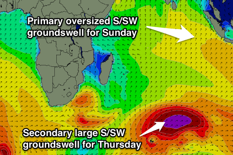
Oversized S/SW swell Sunday, secondary large pulse Thursday
Nias, Mentawai, South Sumatra forecast by Craig Brokensha (issued Thu 21st Aug)
Best Days: Friday afternoon onwards (only for experienced surfers during the large swells)
This Friday through next week (Aug 22 - 29)
The swell has slowly dropped away the last day or so and will bottom out this evening and early tomorrow.
A slight kick in long-range S/SW groundswell is due later tomorrow, holding Saturday from distant polar frontal activity south-west of WA, but to no major size above 5ft in the Ments on the sets, but South Sumatra should see the odd 6ft bomb.
Of much greater importance is an oversized, very powerful and consistent S/SW groundswell due later Saturday and Sunday across Indonesia.
 This swell has been upgraded a touch since Tuesday's large forecast, with the enormous frontal progression generating the swell undergoing a secondary intensification yesterday under the influence of a strong amplification of the Long Wave Trough.
A vast area of open ocean swell over 40ft, about the size of Victoria, has been produced in the Southern Indian Ocean, with side-band energy from this swell due to move up and towards us over the coming days, arriving late Saturday and peaking Sunday morning.
Exposed spots in the Ments are due to offer consistent 10ft waves with 12ft bombs, while Nias will be a touch smaller and South Sumatra bigger with rogue 15ft sets.
Fresh E/SE trades are due in South Sumatra before easing off into the following week as the swell also eases, while the Ments will see generally variable winds. Nias looks to see less favourable W/NW winds from Sunday through Wednesday before backing off and becoming more variable Thursday onwards.
A low point in swell is due Wednesday morning across the region, but this will only be temporary, as a secondary large S/SW groundswell is due later in the day and peak Thursday.
The source of this swell will be another vigorous polar front firing up in the Southern Indian Ocean under the effects of the Long Wave Trough, projecting a fetch of severe-gale to storm-force SW and then W/SW winds towards Bali and then WA.
This system won't be as long-lived and be a touch less consolidated but in saying this, a very large and powerful S/SW groundswell will still result, peaking through Thursday morning to 8-10ft in the Ments, a touch smaller around Nias and with bigger bombs in South Sumatra.
The unfavourable W/NW winds look to move down into the Ments region later next week with lighter more variable winds at Nias and South Sumatra, but we'll review this Tuesday.
16 day Mentawai forecast graph
16 day Nias forecast graph
16 day South Sumatra forecast graph

