Lots of swell, peaking through Saturday; easing next week
Nias, Mentawai, South Sumatra forecast by Craig Brokensha (issued Thu 29th May)
Best Days: Every day over the coming period
This Friday and weekend (May 30th – Jun 1)
There's been no real change to the outlook for tomorrow and the weekend, with a new pulse of SW groundswell today expected to ease off temporarily through tomorrow ahead of a late kick in new S/SW groundswell that's expected to peak Saturday morning.
Size wise the Ments should peak in the 6-8ft+ range Saturday morning with a touch less size around Nias and inconsistent bomb sets to near 10ft at exposed locations in Southern Sumatra. Winds for the most parts are due to be variable tomorrow and Saturday with a weak south-east gradient wind on Sunday as Saturday's swell slowly dips away.
Next Monday onwards (Jun 2 onwards)
There's been no real change to the outlook for next week, with a reinforcing SW groundswell for Monday in the 5-6ft range around the Ments due to slowly dip away through Tuesday and further into Wednesday and Thursday. Thursday will be the low point in swell activity and winds are expected to become light and variable from Monday onwards, persisting into the end of the week.
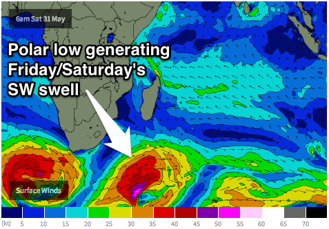
 A new swell that was on the cards for Friday is holding, with a vigorous polar front due to fire up from below South Africa and generate a fetch of severe-gale W/SW winds through our swell window from Friday afternoon through the entire weekend.
The swell from this system is expected to peak later Friday in the 6-8ft+ range in the Ments before tailing off real slowly Saturday and Sunday, with the storm track then favouring more eastern Indonesia into the following week. Check back for another update on Tuesday though.


Comments
Frothing! En route to Medan now
Nice, and next Friday/Saturday's swell is still on track!