Indonesia/Maldives forecast Jun 10

Indian Ocean Basin analysis by Craig Brokensha (issued Thursday 10th June)
This week through next (Jun 13 - 20)
A good pulse of inconsistent SW groundswell seen yesterday should be easing today, but later in the day we should see the forerunners and sizey increase in SW groundswell, generated off a tight low that formed north-east of the Heard Island region over the weekend.
This swell performed well and on forecast across Western Australia with it due to come in strongly later today, peaking tomorrow morning and coming in with power and consistency.
The swell should start to ease later and further Saturday while swinging more southerly in direction.
The next increase in swell is due Monday, with it being an inconsistent groundswell from broad but not overly consolidated polar frontal progression that pushed across the Heard Island region the last few days, though forming initially south-east of South Africa.
It’ll be inconsistent but moderate + in size, peaking Monday before easing Tuesday.
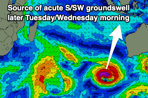
Now, into Tuesday afternoon we’ve got an acute, long-period S/SW groundswell now due, generated by a strong but tight low forming south-west of Western Australia on Friday.
It'll be late in our swell window, but with a tight fetch of severe-gale to nearly storm-force winds, we should see a moderate to large sized spike in swell later Tuesday, easing through Wednesday.
We then look at the large SW swell energy due through the end of the week and beyond, with a great, northward tracking progression of back to back frontal systems due to push up into the Indian Ocean under the influence of the Long Wave Trough.
The first system will project the furthest north but we weakest, generating large pulse of SW groundswell for Friday.
Behind this a stronger more southward positioned progression looks to generate some larger, long-period swell for later Saturday but more so Sunday. We’ll have a closer look at these swells next update though.

Easing E/SE trades are still expected to ease slightly over the coming days, picking up again on Monday before then easing through next week.
Over in the Mentawais, the S’ly swell for later Tuesday/Wednesday will be generated a little too late in the swell window but we should see moderate sized surf.
Variable winds are due this period with a slight freshening from the SE across southern locations this weekend.
----------------------------------------------
Maldives:
Our large mid-period S’ly swell that’s currently breaking across the region will ease a touch this afternoon, with reinforcing levels of mid-period S/SE swell due through tomorrow and Saturday morning before easing.
This is thanks to the swell generating E/SE-SE trades south-east of us breaking down, with a new fetch of healthy trades expected to form south of us early next week, slowly migrating east.
This should produce building levels of mid-period S’ly swell again from later week.
Otherwise the activity south-east of South Africa firing up earlier this week should produce a moderate sized, inconsistent S/SW groundswell for later Saturday but more so Sunday, easing Monday.
The stronger activity firing up under the influence of the Long Wave Trough should generate some larger S’ly groundswell for Thursday next week, but we’ll confirm this Tuesday.
Our current strong W’ly winds (weaker SW across southern locations) will shift more SW through the weekend (slightly weaker Saturday), with the strength due to abate through next week, most noticeable from Tuesday. Winds across the southern locations will shift more S/SE.
Eastern Indonesia:
Large S/SW groundswell for later today, peaking tomorrow morning to 8ft across exposed breaks, easing into the afternoon and Saturday.
Inconsistent moderate + sized SW groundswell building later Sunday, peaking Monday to 5-6ft across exposed breaks.
Moderate-large, acute S’ly groundswell for later Tuesday to 6ft to possibly 8ft across exposed breaks, easing Wednesday from a similar size.
Larger SW groundswell Friday to 8ft across exposed breaks with a secondary larger swell possible for the weekend.
Slightly easing E/SE trades over the coming days, picking up again on Monday before then easing through next week.
Uluwatu 16-day Forecast Graph/WAMs
Western Indonesia/Mentawais/South Sumatra:
Moderate to large S’ly groundswell for later today but more so tomorrow morning to 6ft+ across exposed breaks.
Moderate + sized S/SW groundswell for later Sunday and Monday to 5-6ft across exposed breaks.
Moderate sized S’ly groundswell for later Tuesday/Wednesday to 4-5ft across exposed breaks.
Large SW groundswell to 8ft likely next Thursday afternoon/Friday.
Likely large, reinforcing SW groundswell for the following weekend.
Variable winds this period possibly freshening from the SE across southern locations into the weekend.
Mentawai 16-day Forecast Graph/WAMs
Maldives:
Slowly easing, moderate + S/SE swell Friday/Saturday, more noticeable from Sunday.
Moderate sized, inconsistent S/SW groundswell for later Saturday, peaking Sunday to 4ft across the southern atolls.
Larger S’ly groundswell for Thursday to 6ft+ across the southern atolls, smaller central atolls.
Strong SW winds over the coming days, weaker to the south, with weakening winds into next week (more so from Tuesday), S/SE across southern locations.
Comments
Latest notes are live.
Some beautiful waves today, tomorrow looks even better, rest of the month not too shabby either .
How are the crowds this year ? Same as they have been for a while or getting noticeably worse ?
Shame the tides stop all day waves where you are
One day there’s 40 out next day there’s 3 , very strange and yes you need to pick your windows when tides are big on new & full moon’s. If there’s decent size swell on the mid tides then surf all day . Come august/september there will be 80 out , 65 will have man buns , that will reduce to 15 once double overhead .
hey craig, might be getting greedy, but any chance of a season forecast for Indo? I think you did one last year and I really enjoyed it. or perhaps it was tied into an article on El Nino / La Nina stuff... Cheers
Hey OG, when a clear climate driver appears I generally do, it looks like we could see a - IOD event forming into spring which would bring weaker trades and even NW winds to Sumatra and the surrounding islands, and then less swell in general for the Maldives from the SE. I'll continue to track this.
Some double overhead sets yesterday, report was spot on . Looking forward to today’s notes , the swell around 22, 23 ,24 in particular.