Indonesia/Maldives forecast Mar 20

Indian Ocean Basin analysis by Craig Brokensha (issued Thursday 20th March)
This week through next (Mar 21 - 28)
The size has eased slowly over the past couple of days, with a small, inconsistent S/SW groundswell on the cards for later tomorrow and Saturday morning. Don’t expect any major size but it will prevent the region from bottoming out.
Into Sunday, our new mid-period S/SW swell is on track, with the same swell filling in across Margaret River today. The source was a healthy but not overly strong polar frontal system projecting towards Western Australia earlier this week.
The swell is due to arrive overnight Saturday and fill in through Sunday, peaking through the afternoon before slowly easing Monday.
It looks moderate in size though at the same time (though more so from the weekend), a strengthening monsoonal surge and local W/NW winds will produce moderate levels of lower period W’ly swell for the weekend, abating from Tuesday as winds start to relax.
It’s worth keeping in mind that EC has this monsoonal surge coming in stronger than GFS, so expect an upgrade in the wind strength and size compared to current modelling.
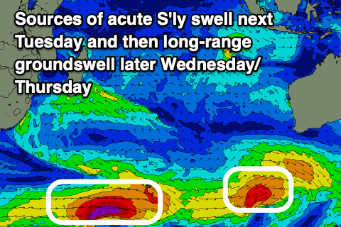
Also in the mix on Tuesday should be an acute but small to moderate sized S/SW swell generated by a late intensifying low south-west of Western Australia today and tomorrow. It’ll be inconsistent and south but worth keeping an eye out for.
We then look at the inconsistent, S/SW groundswell due into later Wednesday but more so Thursday, with the strong polar low linked to it, currently pushing towards the Heard Island region while generating fetches of severe-gale to near storm-force W’ly winds. This low will weaken slowly while projecting more east-northeast, extending the longevity of the swell as it tweaks a little more south in direction.
The swell will be inconsistent but in the moderate to large size range when the sets arrive, peaking Thursday morning with nothing too major to follow.
Winds look to back off and tend variable N’th by Wednesday, but we’ll review this in the next update.
In the Mentawais, strong NW winds across southern locations (variable to the north) will start to abate from today, weaker tomorrow though still lingering into the weekend. A re-strengthening of the NW flow is likely through next week with variable winds initially due across northern locations, possibly tending W/NW-NW later week.
----------------------------------------------
Maldives:
SE swell wise the energy is weak right now, but a small pulse of new, mid-period swell is due into Sunday and Monday morning, generated by a brief strengthening of SE trades to the south of Sumatra. This fetch will break down over the coming days, resulting in a drop in size from Monday afternoon with no real new energy due until the week starting the 31st of March.
S’ly groundswell pulses will then be the most dominant energy across the southern atolls and magnets with a new pulse due this afternoon/tomorrow morning, easing into the weekend ahead of a tricky pulse of S’ly groundswell from ex-tropical Cyclone Jude.
The swell looks smaller than that due over the coming days with it being inconsistent and building through Sunday before easing slowly Monday.
The strong polar low currently west of the Heard Island region should produce a good, moderate sized S’ly groundswell for next Wednesday, likely coming in around the 4ft range.
Eastern Indonesia:
Small, inconsistent flukey S groundswell later tomorrow and Saturday morning.
Moderate sized W’ly swell building through the weekend, peaking Monday, easing slowly Tuesday.
Moderate sized mid-period S/SW swell building Sunday to 4-5ft+ across exposed breaks, easing slowly Monday from a similar size.
Small inconsistent S’ly groundswell for next Tuesday to 3-5ft, easing Wednesday.
Moderate to large sized, inconsistent S/SW groundswell building later Wednesday, peaking early Thursday to 6ft to occasionally 8ft across exposed breaks, easing slowly Friday.
Strengthening W/NW-W/SW winds tomorrow, stronger W/NW from the weekend through Tuesday, easing into the afternoon and becoming more variable N Wednesday.
Uluwatu 16-day Forecast Graph/WAMs
Western Indonesia/Mentawais/South Sumatra:
Easing surf tomorrow.
Small, inconsistent mid-period S/SW swell for Monday to 4-5ft across exposed breaks, with a similar sized, reinforcing swell Tuesday.
Moderate to large sized, inconsistent S/SW groundswell building later next Wednesday, peaking Thursday and reaching 6ft+ across exposed breaks, easing slowly Friday.
Easing NW winds into tomorrow across southern locations (variable to the north). Re-strengthening NW flow through next week across southern locations with variable winds initially due across northern locations, possibly tending W/NW-NW later week in the north.
Mentawai 16-day Forecast Graph/WAMs
Maldives:
Moderate sized S/SW groundswell building this afternoon to 4ft on the southern atolls, easing from a similar size tomorrow morning.
Small bump of SE trade-swell to 3ft across exposed breaks Sunday afternoon and Monday morning, easing.
Small to moderate sized, inconsistent S’ly groundswell building Sunday, reaching 3ft+ across the southern atolls late, easing from a similar size Monday.
Moderate sized, inconsistent S/SW groundswell Wednesday to 3-5ft across the southern atolls, easing slowly Thursday.
Variable winds this period across southern regions, tending more W/NW later next week.
Weak E-E/NE winds across northern and central locations.
Comments
Latest notes are live.
Cheers Craig. Got me days pencilled in
Thanks Gaz!
Thanks Craig for the reports I noticed a cyclone is moving in near the end of the week was leaving on Tuesday so for the third time in two months Ive cancelled. Starting to think the Bali Gods are over me.
I will just wait until the conditions improve. Please keep the reports coming in.
It was blowing an onshore gale on NL this morning but turned glassy about 1 hour ago , clearing up nicely but it’s like the calm before the storm as wind & waves look to be out of control come the 24th