Indonesia/Maldives forecast Aug 20

Indian Ocean Basin analysis by Craig Brokensha (issued Tuesday 20th August)
This week through next (Aug 21 - 30)
Our large, strong mix of SW and S/SW groundswell filled in right on cue yesterday across eastern Indonesia with great waves for the opening rounds of the Padang Padang Cup.
This swell is due to ease today and further tomorrow ahead of our large but less consistent SW groundswell into Thursday. The source was a strong but distant storm forming south-east of South Africa, with the swell due to peak into the afternoon across eastern Indonesia, earlier to the west with less consistent sets compared to the recent swell.
It’ll then be down, down, down through the weekend ahead of our large SW groundswell into early next week.
Now, the models are still wrestling with the strength and intensity of the swell generating storm linked to Tuesday’s swell, with the generally more reliable European, EC solution being consistently stronger than the American GFS solution.
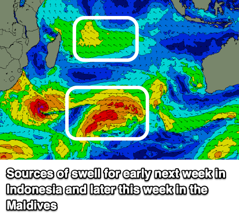
What we’re looking at is a strong, small storm that’s currently south of South Africa, hooking up into the Indian Ocean while generating fetches of gale to what looks to be severe-gale W/SW winds, projecting closer towards us and the WA coast while it weaken slightly later week and into the weekend.
If the models go EC’s way we’re looking at a large, powerful SW-S/SW groundswell that’s due to build strongly later Monday but peak next Tuesday morning just over the size of what was seen yesterday.
If it goes GFS’s way it looks a few feet smaller so check back here on Thursday for the latest on how the storm is developing.
After this swell we’ve got plenty of follow up activity more so into the following weekend and beyond but we have to first, verify the strength and size of the swell for early next week.
----------------------------------------------
In the Maldives, we should be seeing a large S’ly groundswell impacting the region this afternoon, holding tomorrow morning and then easing into the afternoon and further through the week.
This will be at the same time as the SE energy backs off, with some new S/SE trade-swell due to show from Thursday but more so into Friday and through the weekend, easing off very slowly next week.
The source is a great fetch of strong SE trades that have developed south of the islands, with the fetch moving a little west and out of our swell window over the coming days.
It then looks like the fetch will weaken and migrate east through the weekend, resulting in smaller levels of SE swell into next week.
Looking back to the storm mentioned above for early next week across Indonesia, and this should generate a good pulse of S’ly groundswell for the southern regions next Tuesday, with the size dependent on which way the models go as well. At least moderate + sized sets are due, if not more towards the large range but check back here Thursday for the latest.
Longer term, the remnants of a Southern Ocean storm may squeeze against a strong high to the south-east of Madagascar, sending some sizey S/SE swell to the region later next week. More on this Thursday.
Looking at the local winds and the current windy conditions are due to settle over the period as the tropical depression to our south weakens and relaxes pressure gradients.
Eastern Indonesia:
Easing S/SW groundswell tomorrow.
Large, less consistent SW groundswell for Thursday afternoon/Friday morning to 8ft across exposed breaks.
Large SW groundswell building later Monday, peaking Tuesday morning from the S/SW to 10ft across exposed breaks, easing thereafter.
Moderate to fresh E/SE-SE trades this week, light and variable tending locally offshore every morning. Lighter S/SE-SE winds next week.
Uluwatu 16-day Forecast Graph/WAMs
Western Indonesia/Mentawais/South Sumatra:
Large, less consistent SW groundswell building tomorrow afternoon, peaking Thursday morning to 8ft across exposed breaks.
Easing swell Friday and into the weekend.
Large S/SW groundswell building Monday afternoon, peaking Tuesday morning to 8-10ft across exposed breaks, easing the rest of the week.
Fresh to strong S/SE-SE trades across southern locations from tomorrow, reaching northern locations Friday and holding through the weekend. Winds slowly easing through next week but persisting from the S/SE-SE across southern locations.
Mentawai 16-day Forecast Graph/WAMs
Maldives:
Easing SE trade-swell over the coming days.
Larger S’ly groundswell building this afternoon to 4-6ft on the southern atolls, easing tomorrow.
Moderate sized S/SE trade-swell building Thursday, peaking Friday - through the weekend to 4-5ft across exposed breaks, easing slowly next week.
Smaller SE trade-swell for next week.
Moderate + sized S’ly groundswell for mid-next week to 4-6ft on the southern atolls.
Moderate to fresh W/NW-NW winds tomorrow across most locations, easing across the south Thursday and tending more N/NE. NW winds persisting to the north.
Winds tending variable during Friday and then tending W-W/SW through the weekend across northern and central locations, S’ly to the south, similar next week.
Comments
Latest notes are live.
Gday Craig, with "A state of transition is at play" looking further afield, what does this mean for the Indian Ocean - will this potentially mean a slow shoulder season September & October for Indo?
Things will slow from the current activity, but we're talking more so the start of September.
Thanks Craig - Looking forward to your next article - all things ENSO, IOD, SAM etc.
Thanks again Craig, for where I am currently , your size prediction is on the money .
Awesome!
Big kick at g-land today from what I saw.
Just had a mate return from a 12 day boat trip to the Nth. Atolls in the Maldives, he got totally skunked with the first day of a dropping swell @ 3 to the odd 4ft surf with glassy conditions. That was the big day as the nxt. 11 days consisted of devil winds with constant rain squalls & 2ft or less of onshore slop! He said you couldn't even go fishing due to the wind & rain squalls! I guess sometimes you just don't get lucky!
Bummer, yeah the winds the last week and a bit have been terrible for up north and through central locations. They don't get the size from the south swells either.
Sounds like that's been a real consistent problem this season in the northern atolls. Wonder if it's also related to the SAM?
I think it's been more so linked with the MJO signal being stuck in the region (bringing west winds) as easterly trades feed in from the Pacific thanks to the developing La Niña. Troublesome indeed.
It is when I am off there end of next week. Any rough ideas from 31 Aug?
Farking pumping today , some of those 8ft bombs mentioned in the notes hit the reef and were doubling up waves that cleaned up the line up , broken boards and leashes , heart was pumping, further outside up the reef some really good surfers were absolutely getting barreled off their nut .