Indonesia/Maldives forecast Jul 9
Indian Ocean Basin analysis by Craig Brokensha (issued Tuesday 9th July)
This week through next (Jul 10 - 19)
Following Friday’s large S/SW groundswell, the size slowly eased into the weekend, with a reinforcing S/SW groundswell slowing the trend into Sunday afternoon.
Currently we’ve got a new, mid-period SW swell on the build, generated by a healthy but not overly strong storm projecting up near Madagascar last week, with it due to peak overnight/tomorrow morning, easing into Thursday.
We then look at out swells due from Friday, with an initial mid-period increase due to be followed by a better, stronger S/SW groundswell Monday.

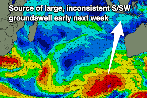
The source is a high riding cold outbreak to the west of Western Australia, with it originating over near the Heard Island region over the weekend. A projection of sub-gale-force W/SW-W winds up towards us should produce a large surge of swell Friday, but on the polar shelf a much stronger storm is now developing.
This polar frontal progression is forecast to generate a fetch of gale to near severe-gale W/SW-SW winds up through our southern swell window over the coming days, producing a larger S/SW groundswell for later Sunday but more so Monday morning. It'll be stronger but less consistent than Friday's.
Following this, the swell will fade, with some new energy on the cards for late in the week but not to the size of the coming energy.
----------------------------------------------
After easing through the weekend, a renewal of S’ly and S/SE swell has been seen across the region yesterday and this morning, with a slow drop in energy expected most of this week.
This is due to the break down in trades and lack of Southern Ocean activity, but later week we should see a mid of moderate sized S/SE groundswell followed by SE trade-swell into the weekend.

The groundswell has been generated by the northward projecting frontal system up across the Heard Island region with it building Thursday, peaking into the afternoon/early Friday morning.
As this swell eases, a strengthening of E/SE trades between Madagascar and Australia will generate a large sized pulse of SE swell that should arrive overnight Friday, building further through the weekend, holding early next week and then easing slowly from about Tuesday afternoon as the swell direction tweaks a little more S/SE.
There’ll also be some smaller, background S’ly groundswell energy but below the size of the trade-swell.
Eastern Indonesia:
Moderate sized mid-period SW swell building today, reaching 4-5ft+ late, easing from a similar size tomorrow morning.
Moderate + sized mid-period SW swell for Friday to 6ft+ across exposed breaks.
Less consistent, stronger S/SW groundswell arriving later Sunday, peaking Monday morning to 6ft+, easing into the afternoon and Tuesday/Wednesday.
Moderate to fresh E/SE-SE trades, variable winds each morning.
Uluwatu 16-day Forecast Graph/WAMs
Western Indonesia/Mentawais/South Sumatra:
Moderate + sized mid-period SW swell for today, building to 4-6ft across exposed breaks during the day, easing tomorrow.
Moderate sized + mid-period S/SW swell Friday to 6ft+ across exposed breaks, easing Saturday.
Less consistent, smaller, reinforcing S’ly groundswell building Monday, reaching 6ft into the afternoon, easing Tuesday.
Moderate + sized SW groundswell for Tuesday afternoon/Wednesday.
Variable winds, tending S/SE-SE across southern locations into the weekend, persisting next week.
Mentawai 16-day Forecast Graph/WAMs
Maldives:
Moderate + sized mix of S’ly groundswell and smaller S/SE trade-swell today to 4-5ft+, easing later and further tomorrow/Wednesday.
Moderate + sized S/SE groundswell building Thursday, reaching 4-5ft across the southern atolls late, easing from a similar size Friday morning.
Large SE tending S/SE trade-swell building over the weekend, reaching 6ft+ on the magnets Sunday/Monday, easing slowly Tuesday.
W/SW-SW winds over the coming days, S-S/SE across southern locations. W/SW-W winds on the weekend and next week with S-S/SW winds in southern locations.


Comments
Latest notes are live.
Thanks Craigos!
Where you off to Tubblett?
New forecast notes coming?
About to start.