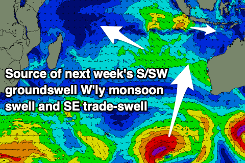
Indonesia/Maldives forecast March 7
Indian Ocean Basin analysis by Craig Brokensha (issued Thursday 7th March)
This week through next (Mar 8)
Following the recent run of good waves, the swell has been on the decline the last couple of days, but we should see some new, moderate + sized mid-period S/SW swell building through tomorrow, peaking Saturday morning.
The source of the swell was back to back frontal systems firing up around the Heard Island region, pushing east, under Australia. The swell came in well across Western Australia and this gives us confidence that it’ll perform well in eastern Indonesia.
The swell will have a slightly longer tail due to the drawn out nature of the frontal progression, though come Monday it’ll be on the smaller side of the coin.
We’ve then got a funky W’ly swell due from Tuesday/Wednesday next week, generated by a broad, deepening area of low pressure (active monsoon trough) to the south of Sumatra, with it remaining stationary through most of the forecast period while spawning off stronger, embedded lows.

This will produce windy conditions across the Mentawais with poor quality winds and swells for Java and further east, starting Tuesday and continuing all week and the following weekend, before slowly fading into the week starting the 18th of March.
With this, exposed breaks will be poor and awash with sizey mid-period swell energy thanks to the strong W’ly winds, cleanest in protected spots, with a couple of S/SW groundswells on the way.
The first will be quite south, generated by a strong, slow moving polar low that’s due to form around the Heard Island region this weekend.
The slow moving nature of the low should generate a moderate + sized S/SW groundswell for next Thursday, building through the day ahead of a peak in the evening, easing slowly Friday.
Behind this, a less consistent mid-period SW swell is likely mid the following week, but we’ll review this Tuesday.
Across to the Maldives, the swell is easing in size from the S’th, but a fresh pulse of S’ly swell energy is due tomorrow, generated from the activity around Heard Island next Friday.
A peak is due through the afternoon, easing slowly Saturday, with building levels of small, SE trade-swell due through next week. The source will be the southern flank of the active, monsoon trough with a healthy fetch of strong E/SE winds setting up through the Maldives swell window,
Moderate sized surf is due from this source, peaking through the middle to end of next week.
Southerly swell sources look slim until the following weekend, more on this Thursday.
Eastern Indonesia:
Moderate + sized mid-period S/SW swell building tomorrow, peaking early Saturday morning to 5-6ft across exposed breaks.
Moderate to possibly large levels of mid-period W’ly swell building through next week, fading slowly the following week.
Moderate + sized, inconsistent S/SW groundswell building Thursday, reaching 5-6ft across exposed breaks, easing next Friday.
Light to moderate W/NW-NW winds tomorrow, freshening from the W through the day then strengthening from the W/NW-W into the weekend. Winds easing into Tuesday through Friday temporarily before possibly freshening again next weekend.
Uluwatu 16-day Forecast Graph/WAMs
Western Indonesia/Mentawais/South Sumatra:
Moderate sized, mid-period S/SW swell for tomorrow afternoon and Saturday morning to 4-5ft across exposed breaks.
Moderate sized, junky mid-period W’ly swell also in the mix from tomorrow, becoming later early next week.
Moderate sized S’ly groundswell for Thursday afternoon, reaching 5-6ft across exposed breaks, easing Friday.
Strong W’ly winds today, tending NW tomorrow and persisting most of next week.
Mentawai 16-day Forecast Graph/WAMs
Maldives:
New mid-period S’ly swell for tomorrow, building to 3-4ft across the southern atolls, easing slowly on the weekend. Smaller to the north.
Moderate sized SE trade-swell building next week, peaking mid-late week to 3-4ft.
Moderate sized S’ly groundswell showing later next week/weekend, coming in at 4-5ft across the southern atolls.
Moderate N-NW winds over the coming days, tending N/NE and then E through next week.


Comments
Latest notes are live.
Cheers Craig , had a rest day yesterday to give the aching muscles a break . Few fun ones this morning at the local wave magnet . Looking forward to weekend but wind might be a tad strong , wait and see .

Hi Craig just wondering if the pre-2023 Indo forecaster notes are available anywhere? Great for hindcasting
Yeah, just go through here.. https://www.swellnet.com/reports/indonesia/bali/uluwatu/forecaster-notes
Thanks Craig. Unfortunately I can only see back to June 22 2023 via that link. I’m looking for the 2018, 2019 ect notes. Great reference for predicting possible swell and wind conditions for specific months, in certain area. Particularly useful given la nina/ El Niño conditions. Testament to the quality of your reports
Agh, there'll be somewhere else. Let me check.
thanks
Hmm, can't find them aghh.
Today was absolutely pumping , sheet glass for a few hours and consistent 4-5ft with 4-6 wave sets . Totally surfed out , it wasn’t cloudbreak and I’m thankful for that . Went fishing at sun up and got skunked, surf on return more than made up for it .
Yeow! Great to hear, wonder if the peak will happen today rather than tomorrow AM.
@craig , definitely bigger today , unfortunately not getting into lacerations , too much south in it but shipwrecks and razors are firing and some clean up sets kept the crowd down to a minimum .
Geez those inbound westerlies look nasty.
Was very fun. It’s fucken amazing how much water time you can clock up in Indo. There’s perfect waves, no doubt but the sheer number of surfable and highly rippable days linked back to back. Best waves in the world without a shadow of doubt.
The hours spent surfing are governed by how long you can handle the fatigue and heat. Waves aren’t an issue.