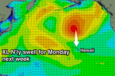
Unseasonal N'ly swells with plenty of wind
Hawaii North Shore, Micronesia and PNG forecast by Craig Brokensha (issued on Thursday 8th March)
Best Days: Protected breaks open to the north swell and out of the wind over the coming period
This week and next (Mar 9 - 16)
Hawaii: A fun increase in NW groundswell yesterday afternoon, easing back from the 4-5ft range this morning, mixed in with some N/NE groundswell. Fresh NE winds are creating less than ideal conditions though.
The NW swell will fade through tomorrow as some larger N/NE swell will fill in, generated by a secondary intensification of a low sitting currently to our north-east.
 This swell will be mid-period energy and not amazing, coming in around 6ft+ at exposed spots to the north-east swell later tomorrow, holding a similar size Friday before easing off slowly through Saturday.
Winds will remain average to poor and gusty from the NE tomorrow through Sunday, swinging a little more E/NE into early next week though strengthening as a new large-extralarge N'ly groundswell fills in.
This will be a result of a large blocking high over our main north-western swell window steering a strong front from the Bering Sea down towards us over the weekend.
A broad fetch of N/NW gales will be projected southwards towards us, producing 12-15ft surf across north friendly breaks Monday, but with those fresh to strong E/NE trades.
The swell will ease back through the week with no decent NW groundswell to follow at all as a convoy of blocking highs setup through the North Pacific Ocean.
North Shore Forecast Graph
North Shore WAMs
Micronesia: There isn't much on the cards for the coming forecast period with fading small levels of N'ly swell tomorrow and small amounts of NE trade-swell sneaking in to protected spots mid-late next week.
This will be from the a strong but slightly retracted fetch of E/NE gales sitting north-east of us this weekend. Size wise we're only looking at small sets to 2-3ft in protected spots out of the E/NE trades, fading into next weekend.
Palikir Pass Forecast Graph
Palikir Pass WAMs
Papua New Guinea: Small surf over the coming period, with background NE trade-swell fading from the weekend back to an inconsistent 2ft max. Into later next week we should see some new NE trade-swell filling in, produced by those trades north-east of Micronesia.
Sets to 3-4ft are expected to develop later Thursday, peaking Friday and then easing slowly Saturday with variable winds form the W/NW.

