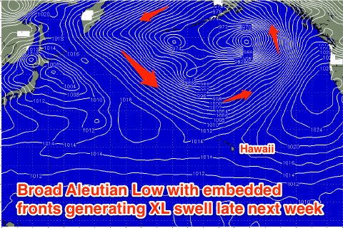
Tons of swell to come, likely XL late next week
Hawaii North Shore forecast by Craig Brokensha (issued Thursday 7th January)
Best Days: Experienced surfers every day besides Saturday with poor winds
This week and next week (Jan 5 - 15)
This morning we fell in between swells, but a fresh pulse of N/NW groundswell filled in through the afternoon boosting exposed breaks back to 8-10ft or so by dark.
This groundswell should ease back through tomorrow from 6ft with the odd 8ft set likely at dawn with variable winds ahead of afternoon sea breezes.
A new NW groundswell due to build Friday and then ease Saturday morning is currently being generated by a vigorous front projecting south-east down towards us. A fetch of gale to severe-gale W/NW winds should produce a moderate to large NW groundswell pulse, building to 8-10ft later Friday and easing from a similar size Saturday morning.
Variable winds are again due Friday morning ahead of afternoon sea breezes, while Saturday looks poor with moderate to fresh W'ly tending N'ly winds.
Of greater significance is a larger N/NW groundswell pulse for Sunday with an upgrade being seen since Tuesday's update.
A secondary tight low racing in from the west later this week will generate a very intense fetch of severe-gale to sub-storm-force W/NW winds just to our north-west, generating a large long-period N/NW groundswell for Sunday morning. A broader trailing fetch of NW gales on the back of the initial low should slow the easing N/NW groundswell through Monday.
This swell should be seen on dark Saturday, with Sunday morning providing solid 12-15ft sets across the North Shore, easing back through the day and further into Monday from 10ft+.
Winds should improve through Sunday with weak E/NE trades and afternoon sea breezes, with variable winds and sea breezes Monday.
Another large N/NW groundswell is due Tuesday across the islands as a low forming on the tail of the progression linked to Sunday's swell projects a fetch of gale to severe-gale NW winds down towards us through out northern swell window over the weekend and early Monday.
Exposed breaks on the North Shore should kick to the 12ft to occasionally 15ft range Tuesday morning with variable winds, easing through Wednesday and further Thursday.
 Longer term we've got at least one if not two XL swells on the cards for later next week and the following.
This will be related to a strong and broad Aleutian low developing mid-next week, with a series of vigorous embedded fronts working on the back of each other, setting in motion a very large NW groundswell event.
At this stage it looks like the close proximity of the fronts to Hawaii could create poor winds with the large swell, but we'll have another look at this on Tuesday.

