Downgraded swell for this week, next decent swell later next week
Hawaii North Shore forecast by Craig Brokensha (issued Tuesday 15th December)
Best Days: Tuesday afternoon through Thursday, later next week
This week and next week (Dec 15 - 25)
Not much in the way of swell the last few days, with a small kick yesterday, easing back from the 3ft range this morning.
Tomorrow morning is expected to be a low point in swell activity, and a large, powerful long-period NW groundswell that was due to kick very solidly into the afternoon has unfortunately gone pear-shaped.
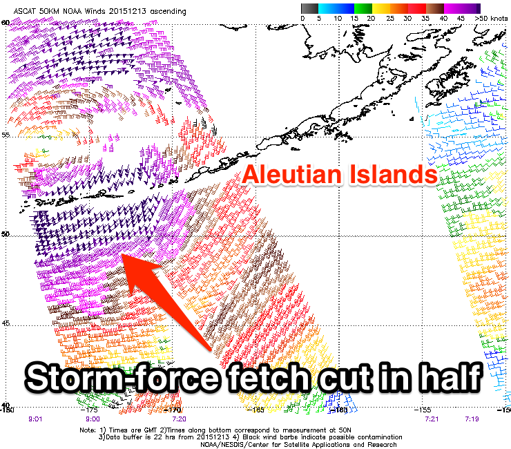
 A 'bombing low' off the Japanese coast the last few days was forecast to slow down and aim a great fetch of storm to hurricane-force NW winds towards Hawaii.
While the low did produce a fetch of this calibre, its track was faster to the north-east perpendicular to Hawaii's swell window, not as favourably aimed and then cut off as it tracked across the Aleutian Islands.
Instead we're set to see a mix of small to moderate NW groundswell pulses of mid and long-period, the first building through tomorrow and reaching 4-5ft+ across the North Shore into the afternoon.
Into Wednesday a stronger pulse is due, coming in around the 6ft range on the sets before dropping back from 5-6ft or so Thursday morning.
Moderate E/NE trades are expected to increase a touch through tomorrow, becoming fresher through Wednesday and gusty to strong Thursday, remaining so through the weekend.
Longer term there's nothing too major due into early next week with a small inconsistent long-range NW groundswell due Tuesday ahead of hopefully a moderate to possibly large pulse later in the week. We'll have a closer look at this on Thursday though.


Comments
Flippy could win easily in this surf.
Still think comp running Thu/Fri Craig?
You mean our time? Ie Wed/Thu Hawaii time, yes.
Sorry yeah Aus morning time, cheers
Surfline calling 8-12 feet so its going to be 4- 6 foot pipe for the finals.
Pretty average winter so far for the North Shore. Wouldn't exactly say its above average surf due to El Nino. Its now mid December and they have had 3 or 4 good swells, 1 xl and one xxl. Wonder if all the action is going to be in the late season??
Pat Caldwell has 12-16ft Wednesday, so 6-8ft, but I'm sticking with my sets in the 6ft range.
Hope it over performs, which it could do seeing the strength of the low, quite impressive!
http://www.prh.noaa.gov/hnl/pages/SRF.php
This is promising for that 6-8ft surf though..
"The jason altimeter at 00Z and 06Z 12/14, or Sunday afternoon and evening locally, had passes over the seas and swell aimed at Hawaii.
Both showed higher waves than estimated by the Wave Watch III model. Thus the numbers for the local forecasts were nosed up a notch. This should be the dominant direction starting Wednesday."
I can't seem to load up his report....solid swell for wed PM on surfline??
Here's Surfline.
WEDNESDAY the 16th: 8-12’ occ. 15’ faces (8’+ Hawaiian) as NW swell likely peaks in the AM, gradually easing for the PM.
Swell/Surf: New, long period NW swell looks likely to peak during the morning, with a very gradual trend down in the afternoon. Stay tuned, we’ll continue to refine details in the next couple days.
Wind/Weather: Moderate E trades in the morning, becoming breezy E/ENE trades over the afternoon.
Here's Pat's report relative to pipe masters
A low pressure deepened rapidly east of Japan Friday 12/11. The center raced NE reaching the Aleutians late Saturday and into the Bering Sea near the dateline Sunday. Central pressure dropped near 930 mb. Highest seas were aimed at Alaska with the jason altimeter validating seas over 50 feet. The portion aimed at Hawaii had lower waves. There were two primary parts.
For wave generation over the 305-320 degree band relative to Hawaii, severe gales over the first 24 hours grew seas to near 25 feet with the head of the fetch about 2100 nm away mid Saturday. Nw Hawaii NOAA buoys 51101 and 51001 show a trace of 19-21 second energy starting to arrive mid day 12/14 from this source. Surf locally from 305-320 degrees should slowly build early Tuesday into the afternoon, with heights approaching the seasonal average late in the day. Energy from this direction should peak Tuesday night and slowly drop on Wednesday into Thursday at levels below average.
Higher winds occurred over the 320-330 degree band mid Saturday into Sunday as the low center deepened. Storm- to hurricane-force winds over a fetch of limited length and duration grew seas near 30 feet for an area about 2000 nm away. The jason altimeter at 00Z and 06Z 12/14, or Sunday afternoon and evening locally, had passes over the seas and swell aimed at Hawaii. Both showed higher waves than estimated by the Wave Watch III model. Thus the numbers for the local forecasts were nosed up a notch. This should be the dominant direction starting Wednesday.
Long-period swell from 320-330 degrees is expected to fill in mid day Tuesday, with heights climbing above average near sundown Tuesday. Heights should peak near sunrise Wednesday with a slow decline. Surf should fall below average on Thursday with the event fading out on Friday.
What a guru!
Watching the explore.org pipe cam [rewind back a few hours] swell def on the rise .
Yeah, very nice, and what a sunset!