Flukey period of north swells

Eastern Tasmanian Forecast by Craig Brokensha (issued Friday August 23rd)
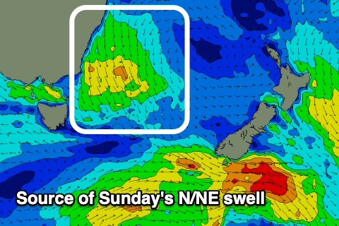
Best Days: Sunday morning
Features of the Forecast (tl;dr)
- Small N/NE swell building later tomorrow, peaking Sun with fresh NW tending N/NE winds
- Easing N/NE swell Mon with W/NW winds
- Possible building N swell later Tue with strong to near gale-force N/NW winds, easing Wed with strong NW tending W/NW winds
Recap
Small levels of easing NE windswell have provided little runners across the magnets the last two days, best yesterday and tiny today.
This weekend and next week (Aug 24 - 30)
The coming outlook isn’t great as we fall under a zonal pattern from mid-late next week which we haven’t seen for quite some time.
This will bring with it lots of westerly swell that will struggle to wrap up into our region.
Ahead of this though on the weekend, small levels of N/NE windswell are due from pre-frontal N winds developing down the southern NSW coast tomorrow.
The swell should build late tomorrow but peak Sunday morning to 2ft across the north magnets with NW tending N/NE winds. Not ideal.
The swell is due to fade Monday from 1-2ft with a W/NW change and then we’re looking at the zonal pattern setting in.

The only chance for another wave across the north magnets will be later Tuesday and Wednesday morning as gale-force N/NW tending NW winds may generate some flukey, radially spreading N'ly energy.
It’s tough to put on any expected size but we may see sets reaching 3ft but with strong to near gale-force N/NW winds Tuesday, strong NW tending W/NW through Wednesday.
Otherwise, besides another tricky N’ly swell next Friday there’s nothing to really work with. Check back Monday for the latest update though. Have a great weekend!