Secondary strong NE groundswell to come
Eastern Tasmania Surf Forecast by Craig Brokensha (issued Wednesday October 4th)
Best Days: Tomorrow southern corners, Friday, Saturday morning
Features of the Forecast (tl;dr)
- Mod-large NE groundswell building tomorrow, peaking later
- Mod-large mid-period S swell peaking midday tomorrow
- Strong S/SW winds tomorrow, tending S/SE to the north in the PM
- Fading NE groundswell Fri with a moderate sized + S windswell
- Mod-fresh W/SW tending stronger S/SE winds Fri
- Easing S swell Sat with W/SW tending E/SE-SE winds
- Tiny Sun with W tending E/NE winds
Recap
Large levels of N/NE windswell developed yesterday with clean conditions through the morning, becoming wind affected into the afternoon. A late change cleaned up conditions for the late session as the swell started to ease and this morning we've got smaller leftover 2-3ft waves with southerly winds.

Early afternoon yesterday

Early evening yesterday with a change and drop in swell
This week and next (Oct 3 - 8)
One swell episode down, another to go.
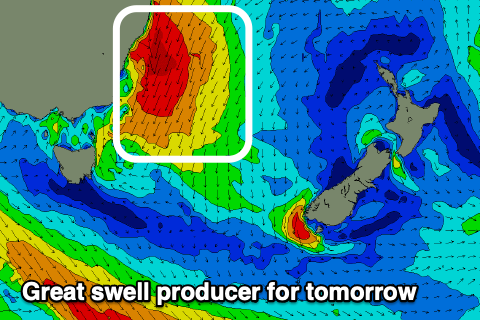
With the localised, large N/NE windswell from yesterday now on the ease, we look at the next swell generating system currently sitting off the NSW coast.
A deepening inland low is moving east, squeezing a strong high and setting up a strengthening fetch of gale to severe-gale NE winds in our close to medium-range swell window.

This will produce a moderate-large, NE groundswell that's due to build through tomorrow and peak later in the day to 4-6ft across the north-east magnets, less consistent than yesterday's energy and with more power.
Also in the mix will be moderate-large levels of S'ly swell from the western flank of the low, projecting a fetch of S/SW gales directly off our coast tomorrow morning. It's a tricky swell source but south magnets may see 5-6ft sets during the middle of the day.
Winds tomorrow will favour southern corners though with strong S/SW breezes that may shift S/SE in northerns locations.
Friday should see a steady drop in NE groundswell and S'ly swell with easing 2-3ft sets across north-east magnets and 4ft surf across the south magnets.
Smaller, fading surf is then due through the weekend, likely still 2-3ft on the south magnets as winds slowly improve.
A moderate to fresh W/SW tending stronger S/SE breeze is due Friday, W/SW tending E/SE-SE on Saturday.
Sunday looks tiny but with W/NW tending E/NE winds.
Longer term there's nothing too significant on the cards for next week so make the most of the coming swells.

