Small swells for the week
Eastern Tasmania Surf Forecast by Craig Brokensha (issued Monday 13th March)
Best Days: South magnets tomorrow morning, Wednesday morning for the keen but more so Thursday and Friday morning
Features of the Forecast (tl;dr)
- Easing S swell tomorrow with W/NW tending gusty N/NE winds
- Easing small NE windswell Wed with W tending E winds
- Building mid-period NE swell Thu with gusty W/NW tending W/SW-SW winds
- Easing E/NE swell Fri with fresh W/NW tending NE winds
Recap
No real swell until later yesterday when S'th energy arrived from a more favourable direction.
This morning was the pick with light winds and surf to 4ft on the south magnets. Sea breezes are now into all locations as the swell slowly subsides.
This week and weekend (Mar 14 - 19)
The current S'ly swell is due to ease back through tomorrow, with south magnets likely to continue around 2ft in the morning before fading through the day. A W/NW offshore will create clean conditions before gusty N/NE sea breezes kick in.
These afternoon winds are due to generate a small 2ft of N/NE windswell for Wednesday which will ease through the day under W tending E winds.

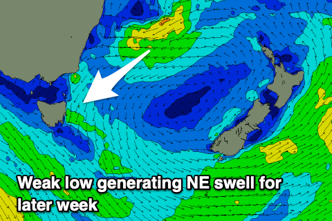
Thursday looks the pick though, with a weak low that's currently sitting in the Tasman Sea, east of NSW due to shift more south-west in alignment, opening up our coasts to a healthy fetch of strong E/NE winds tomorrow, weakening while drifting south-east on Wednesday.
Tomorrow’s fetch should generate a fun NE swell to 2-3ft Thursday, with a peak into the afternoon to a more consistent 3ft.
Winds will be gusty from the N/NW, shifting W/SW-SW through the day, creating fun conditions across north-east magnets.
Come Friday the swell should be fading from 2ft with W/NW offshore winds.
Following this, the outlook remains void of any major swell, with frontal systems passing under us being too zonal to generate any S'ly swell, while the Tasman Sea shows possible signs of potential, but at the moment it's not amounting to much. More on this Wednesday.

