Moderate to large east swell for the weekend
Eastern Tasmanian Surf Forecast by Craig Brokensha (issued Wednesday December 8th)
Best Days: Monday morning, Tuesday
Features of the Forecast (tl;dr)
- Tiny over the coming days with S/SW tending SE winds
- Building E swell Sat with strong S/SE winds, larger Sun PM with fresh SE tending E winds
- Easing E swell Mon with variable tending E winds
Recap
Really fun waves across the beaches yesterday with an improving N/NE windswell before a southerly change whipped through. This morning there's not much left in the tank at all with small peelers in southern corners.
This week and weekend (Dec 9 - 12)
The end of the week isn't too interesting surf wise with S/SW to SE winds and tiny levels of weak E'ly swell.
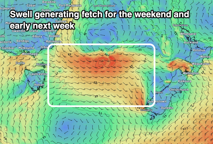
Moving into the weekend though we've got a bit more size and swell on the cards as the surface trough linked to yesterday's southerly changed deeps to our north-east.
 Over the coming days the deepening low will be too far north of us, but as we move into the weekend and it drops south, it'll broaden in scope, opening up our coast to a broad fetch of strong to near gale-force E/SE winds.
This fetch will be slow moving and produce a moderate-large sized E swell that will build Saturday with strong S/SE winds but likely peak Sunday afternoon and Monday morning to 4-6ft across open beaches. Winds on Sunday look to be more SE, shifting more E'ly through the day while a light offshore wind is a high possibility on Monday morning.
The swell will ease Tuesday as the low moves off further to the east and weakens, with dropping sets from the 3-4ft range under NW tending NE winds.
Longer term, there's a high likelihood of a tropical clone forming in the Coral Sea, drifting south-east towards New Zealand while making an extra-tropical transition.
While this all sounds good, there's no real supporting high pressure ridge to support the ex-TC and swell wise I wouldn't expect much at all. More on this and the weekend's swell Friday.

