Swells from the south this period
Eastern Tasmania Surf Forecast by Craig Brokensha (issued Friday 25th June)
Best Days: South magnets Monday and Tuesday, Wednesday and Thursday morning
Features of the Forecast (tl;dr)
- Small, flukey pulses of S'ly groundswell for the weekend
- Better S'ly swell for Mon with W tending N/NE winds, easing Tue with W/NW tending N winds
- Good S/SE groundswell for Wed with fresh N/NW winds, easing Thu
Recap
Tiny N/NE windswell waves for the desperate.
This weekend and next week (Jun 26 – Jul 2)
Trick S'ly swells, that's what we're looking at over the coming period with an initial flukey pulse this afternoon due to ease tomorrow. I'd set my expectations low for this one with maybe the odd stray 2ft wave on the magnets.
 Continued W'ly gales along the polar shelf may keep 1-2ft sets hitting south magnets through the weekend with improving winds tomorrow, W/SW-SW tending NW and then W/SW tending W on Sunday.
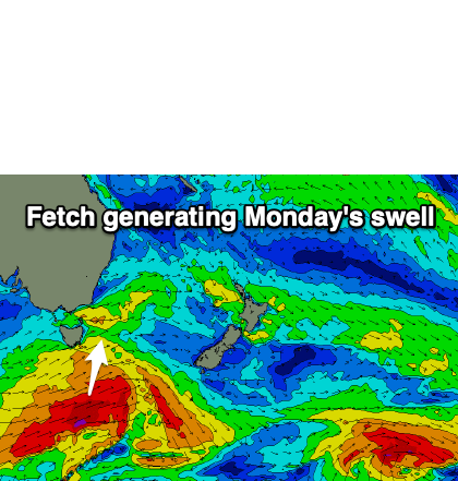
There's a better swell producer Monday, that being a polar low firing up south-west of us, projecting a fetch of W/SW gales through our southern swell window. The front will track a little quick but we should see a good pulse of S'ly groundswell for Monday, coming in at 3-4ft across the south swell magnets, easing later and down from 2-3ft on Tuesday.
Conditions will be great for these locations with a W tending N/NE breeze on Monday and then W/NW tending N breeze Tuesday.
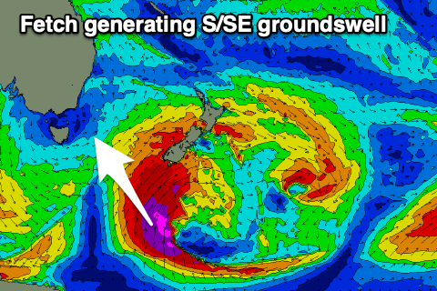
 On Wednesday, a fun, reinforcing S/SE groundswell is due, generated by the backside of the polar low as it pushes onwards towards New Zealand. A great though short-lived fetch of severe-gale S/SE winds will produce the swell, coming in around 3-4ft under fresh N/NW winds.
The swell should still be 2-3ft Thursday and easing as N/NW winds persist.
Longer term there's a couple of possibilities regarding around a mid-latitude low develop in our region next weekend. More on this in Monday's update though. Have a great weekend!

