Low, low, low
Eastern Tasmania Surf Forecast by Craig Brokensha (issued Friday 11th June)
Best Days: Tomorrow, Sunday morning
Features of the Forecast (tl;dr)
- Good E'ly swell for tomorrow AM, easing through the day steadily, down further Sun
- SW tending W/SW winds, then back to the S/SW late tomorrow, W/SW tending S/SE on Sun
- Mix of new E/SE and onshore E/NE swell building late next week
Recap
Large, stormy surf across the state yesterday, coming in more from the east today but with limit options.
This weekend and next week (Jun 12 - 18)
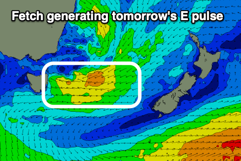
The low linked to our current run of stormy conditions and weather is still aiming a broad fetch of strong E'ly winds towards us but from this evening this will weaken and shift south, resulting in one final reinforcing pulse of E'ly swell tomorrow morning, then dropping steadily.
Size wise, open beaches should come in at 4-6ft at dawn, easing steadily back to 3-4ft into the afternoon, down from 2-3ft on Sunday, tiny early next week.
 Winds will improve for most beaches tomorrow with a SW tending W/SW breeze, then W/NW for a period across the north of the coast before shifting back S/SW.
Sunday will be clean in the morning with a W/SW breeze but a trough will bring a fresh S/SE change into the afternoon.
Longer term, we've got a small intensification of E/SE winds off the South Island of New Zealand Tuesday evening and this should produce a fun, small E/SE swell for Thursday afternoon and Friday to 2-3ft or so.
At the same time as this fills in though, another mid-latitude low forming to our north-east looks to bring E/NE winds and a building E/NE swell, but we'll go over this dynamic outlook again on Monday. Have a great weekend!

