Target the swell when it swings more east
Eastern Tasmania Surf Forecast by Craig Brokensha (issued Friday 28th May)
Best Days: Selected locations tomorrow morning, Sunday, Monday
Features of the Forecast (tl;dr)
- Mid-period S/SE swell tomorrow with fresh SW tending S-S/SE winds, easing Sun from the SE
- Good SE groundswell for Sun PM with W tending variable N winds, easing Mon with W/NW tending NW winds, fading Tue
Recap
Building S'ly swell today but with average winds for the spots seeing the increasing size.
This weekend and next week (May 29 – Jun 4)
Currently we're seeing a broad fetch of strong S'ly winds projected up past our coast but they're strongest and gale-force north of us, resulting in the peak of the swell energy impacting southern and northern NSW.
We're instead seeing mid-period surf and we'll see this easing back in size through tomorrow while tending more S/SE in direction. Easing sets from 3-4ft+ are due across south facing beaches across the northern half of the coast, tiny elsewhere.
 Winds will remain an issue for these northern corners with fresh SW breeze tomorrow morning, shifting S-S/SE into the afternoon.
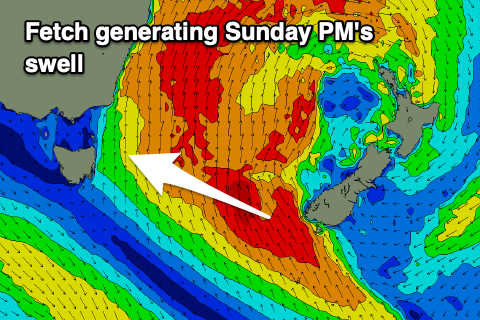
Sunday looks much better as we see a new SE groundswell fill in through the afternoon, generated by a great fetch of gale to severe-gale SE winds off the southern tip of New Zealand's South Island.
Come Sunday morning we'll likely be between pulses with sets to 3-4ft due from the SE, with the groundswell offering a touch more size, possibly providing 5ft sets on the magnets, easing back from 3ft to possibly 4ft on Monday morning, smaller into the afternoon and 1-2ft Tuesday.
Winds will improve and swing W'ly Sunday morning, variable N into the afternoon with W/NW tending NW winds on Monday and Tuesday.
Longer term there's still nothing major on the cards, but check back here next week for the latest. Have a great weekend!

