Strong north-east swell to come
Eastern Tasmania Surf Forecast by Craig Brokensha (issued Wednesday 3rd February)
Best Days: Thursday, later Friday northern corners, Saturday northern corners, Sunday
Features of the Forecast (tl;dr)
- Fun E/SE tending E/NE swell tomorrow with SW tending N/NE winds
- Building N/NE windswell Fri, large and peaking Sat AM with N/NE tending N/NW and then NW winds
- Easing NE swell Sun
Recap
Tiny surf yesterday, continuing today.
This week and weekend (Feb 3 - 7)
We’ve got our fun E’ly swell due tomorrow, generated by trough/low that’s currently east of us and will drop south.
We’ll see a fetch of strong SE, tending E/SE then E/NE winds through today and early tomorrow, generating an E/SE tending E/NE swell. Size wise we’re looking at surf in the 3ft range across open beaches, if not for the odd bigger one and winds will shift from SW to N/NE through the day, so work those corners accordingly.
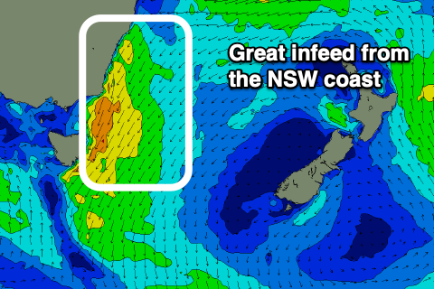
The swell will fade into Friday as our localised N/NE windswell event starts to build, generated by the interaction of a mid-latitude low in the Bight, squeezing a strong high in the Tasman Sea.
 A strong, broad and persistent fetch of NE winds will develop from our coast, up to the southern NSW region, generating a rapid increase in size, building to 4-5ft by dark Friday but with strengthening N/NE winds, peaking Saturday morning to 6ft+.
Winds will shift N/NW to NW slowly through Saturday, poor at dawn, cleaning up the swell as it starts to ease. Late Saturday will be the cleanest with the most size, though Sunday fun in southern corners with a W/NW tending S/SE breeze and easing 3ft to possibly 4ft sets.
Looking at the reinforcing swell from ex-Tropical Cyclone Lucas and this now looks minimal with Lucas due to weaken while well north of our ideal swell window. Not much above an inconsistent 2ft to possibly 3ft wave is due Monday morning (if that), easing through the day.
Longer term there’s nothing too major on the cards, so make the most of the coming swells.

