Very active period from the east to north-east
Eastern Tasmania Surf Forecast by Craig Brokensha (issued Monday 1st February)
Best Days: Thursday morning, protected northern corners for the keen Friday afternoon and Saturday, Sunday, Monday, Tuesday
Features of the Forecast (tl;dr)
- Fading N/NE swell tomorrow with SW tending SE winds
- Fun E swell Thu with NW tending fresh N/NE winds
- Building N/NE swell Fri, peaking Sat with strong NE winds
- Easing N/NE swell Sun with NW tending W/SW winds
- NE swell for Sun/Mon from TC Lucas
Recap
A strong NE swell on Saturday with 4-6ft surf and winds out of the NW ahead of a late S/SE change. Open beaches were great before the attention shifted to southern corners. Yesterday was smaller but OK in southern corners, while today we've got some new N/NE windswell in the water with bumpy surf to 3ft.
This week and weekend (Feb 2 - 7)
This evening we'll see a strong S'ly change as a trough pushes offshore, and this will kill the infeed of NE winds generating today's swell.
 A morning SW breeze should be seen again tomorrow morning, quickly shifting S/SW and then SE but the swell will be much small and only a weak 1-2ft or so out of the NE, if that.
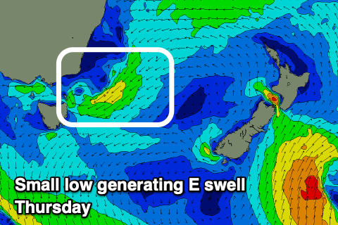
Wednesday looks a lay day with no significant swells and increasing onshore winds out of the SE. This will be linked to the trough forming into a small low north-east of us, and into Wednesday afternoon/evening, a good fetch of E/SE tending E/NE winds will be aimed through our swell window, generating some new swell for Thursday.
Size wise it looks to be around a peaky 3ft or so (if not for the odd sneaky bigger one) and winds will shift around as the low pushes south through the day. The morning looks best with a light NW'ly ahead of fresh N/NE sea breezes.
Now, moving into the end of the week and weekend, the tropical activity north of New Zealand now looks too off axis and aimed north-west, towards New Caledonia and Vanuatu. This isn't expected to generate any swell for us, but looking further west, Tropical Cyclone Lucas which is currently just south of the Solomon Islands, is due to drift south, down across New Caledonia on Wednesday, squeezing a ridge of high pressure that'll move slowly across New Zealand.
 Lucas is then expected to weaken but continuing tracking south-west towards us while making an extra-tropical transition. This is due to occur on the weekend, with the remnants feeding into a broad low that'll be drifting in from south of South Australia.
What this all means is that we'll see a local increase in NE windswell Friday and Saturday from the strengthening NE winds feeding into the low, followed by mid-period NE swell from the remnants of Lucas Sunday/Monday.
Conditions will be poor with strong NE winds Friday and Saturday but building surf to to the 6ft+ range, pumping from Sunday as the low pushes east bringing an offshore change along with easing 4-5ft surf, still fun and to 3-4ft Monday with the stronger swell from Lucas.
This is still a fair way out but the models are converging on this outlook, though check back Wednesday/Friday for a clearer idea on the coming developments.

