Fun surf days for the period
Eastern Tasmania Surf Forecast by Craig Brokensha (issued Wednesday 20th January)
Best Days: Tomorrow, swell magnets Friday morning, south swell magnets late Saturday and Sunday ahead of the change
Features of the Forecast (tl;dr)
- Easing S/SE swell with favourable winds for south magnets until later Fri
- New S'ly groundswell building Sat PM, holding Sun with favourable winds for south magnets
Recap
A strong pulse of S'ly groundswell yesterday though the spots picking up the size were copping the wind and protected spots not seeing too much size. Today is cleaner and with plenty of fun surf between 3-5ft with a S/SE groundswell also in the mix.
This week and weekend (Jan 21 - 24)
Down, down, down.
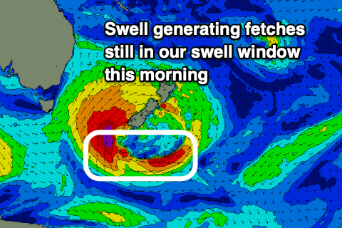
 That's the trend from here with the swell generating low moving over to New Zealand and out of our swell window. In saying that a small fetch of S/SE gales feeding into the southern flank of the low is still within our south-east swell window and should soften the easing trend into Friday.
Looking at tomorrow and south magnets should still see 3-4ft sets in the morning, easing back to 3ft through the afternoon, with Friday down from 2-3ft, though inconsistent.
Winds will be favourable and NW tomorrow ahead of fresh NE sea breezes, NW most of Friday ahead of a S/SE change late afternoon that might not push north of St Helens.
Saturday looks to start small to tiny, but a new S'ly groundswell for the afternoon is on track, with the polar low linked to it now due to be stronger and slower moving.
We'll see it form within our swell window Friday, with a great, elongated fetch of W/SW gales being stretched out through our swell window, with the low continuing slowly east-northeast towards New Zealand on Saturday. This will prolong the swell event.
 Size wise south magnets should build to 3ft+ Saturday afternoon/evening with 3-4ft sets Sunday, easing Monday.
Winds look decent as well, shifting NW later Saturday with a surface trough and then variable W Sunday ahead of a shallow SE change.
Longer term we may see the trough develop into a low in the southern Tasman, generating some new E swell, but more on this Friday.

