Tricky south followed by north
Eastern Tasmania Surf Forecast by Craig Brokensha (issued Wednesday 9th December)
Best Days: Saturday morning and late across south swell magnets, later Sunday south swell magnets, Monday morning south swell magnets
Recap
A good pulse of S'ly groundswell filled in across the regions south swell magnets yesterday afternoon, easing back through today.
This week and next (Dec 10 - 18)
Looking at the coming few days, we've got fun though pulsey and generally small S'ly swells on the way.
A conveyer belt of polar fronts skirting around a strong high that's moving under the country are generating a constant flow of westerly winds through our south swell window.
 Currently a weak though broad polar front is pushing up and towards us, with it due to push across the region overnight.
A mix of mid-period and S'ly windswell is due to build tomorrow, reaching 2-3ft across south facing beaches into the afternoon but with poor and strengthening SW tending S/SE winds.
A secondary broad polar front following a similar track should produce a reinforcing and similar sized pulse for late in the day Friday and Saturday morning to 3ft, with Friday morning likely falling in between and back to 2ft+.
Following this, one final pulse of S'ly groundswell may be seen late Sunday but the source of this swell is in our far swell window and sets only to an inconsistent 2-3ft are likely, easing Monday.
Coming back to the local winds and a morning W/SW breeze will give into onshore E'ly winds Friday, which isn't ideal, similar Saturday but cleaning up later with SW tending SE and then NE winds.
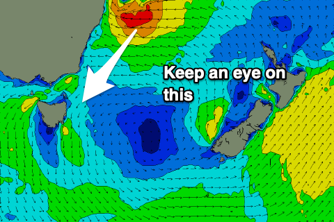
Sunday looks to see strengthening N/NW tending N/NE winds as a strong high in the Tasman Sea is squeezed by a deepening trough sliding down the NSW coast and this will bring with it a good sized N/NE swell event.
 As touched on last update, this strong high will initially set up a great trade-fetch aimed at the Qld and NSW coasts, but a tropical depression forming on its northern flank is forecast to slide south towards the Sydney region.
This will aim a fetch of strengthening NE winds through our northern swell window Sunday/Monday, producing a moderate sized N/NE groundswell for Tuesday/Wednesday. Size wise it's too early to nail down the sizes so check back here Friday for more details.

