Pulsey south swells, then possibly north-east
Eastern Tasmania Surf Forecast by Craig Brokensha (issued Monday 7th December)
Best Days: Tomorrow afternoon south swell magnets, Wednesday morning south swell magnets, Saturday south swell magnets
Recap
A fun mix of building S'ly swells and N/NE energy on Saturday afternoon, fading yesterday.
This week and weekend (Dec 8 - 13)
Looking at the week ahead and we've got small pulses of S'ly swell on the way, then followed by some interesting and possibly juicy east-northeast.
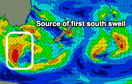
 Currently a broad mid-latitude low with a polar fetch attached to it is moving across us, with a great polar fetch of strong to gale-force S/SW winds being projected through our southern swell window today.
This should produce a fun pulse of S'ly swell for tomorrow, peaking through the afternoon to 3ft+ across the south swell magnets, smaller in the morning.
This swell is due to ease Wednesday from a small 2ft to possibly 3ft on the south swell magnets, with the next increase in size due through Thursday.
 The source of the secondary pulse will be a relatively weak but drawn out polar frontal system, projecting a fetch of strong SW winds through our swell window Wednesday evening and more so Thursday. Following this another weak front should move through our swell window Friday, generating a reinforcing S'ly swell for Saturday.
Size and consistency wise these look a little less favourable with small 2ft to possibly 3ft sets due on the south magnets later Thursday, Friday morning and then Saturday.
Coming back to the local winds and tomorrow morning offshore W'ly winds are due to give into NE sea breezes, swinging back W/NW late favouring those south magnets. Wednesday looks to play out similar but come Thursday morning W/SW winds will shift S'ly and become strong, creating poor conditions.
Friday is a bit touch and go with a W/SW tending E/NE breeze, cleaner Saturday with W/NW tending NE winds.
Now, longer term we've got some interesting developments on the cards, but for the most part, expect small surf from the north-eastern quadrant.
We're expected to see a strong high move into the Tasman Sea on the weekend and early next week, squeezed by tropical activity on its northern flank. This should produce a great easterly trade-swell event for the mainland, but whether we'll see the activity being aimed down towards us is still up for grabs.
If we do see a dip in the easterly trade-flow we could expect fun waves out of the north-east from mid-next week, but more on this Wednesday.

