So, so weekend, more potential next week
Eastern Tasmania Surf Forecast by Craig Brokensha (issued Friday 27th November)
Best Days: Desperate surfers tomorrow AM, Tuesday afternoon, later next week
Recap
Small levels of E'ly swell yesterday and more so this morning but inconsistent. There was also a hint of south swell in the water and now, building N/NE windswell.
This weekend and next week (Nov 28 – Nov 4)
An approaching trough is squeezing a high in the Tasman Sea, generating this afternoon's building N/NE windswell and an early morning S'ly change will cut off the infeed of N/NE winds.
It'll also bring funky winds tomorrow morning with a variable onshore breeze likely across most locations, freshening onshore around St Helens and Scamander mid-late morning and then swinging NE thereafter.
Size wise the N/NE swell is expected to ease from 2ft, tiny Sunday with a strengthening S'ly change.
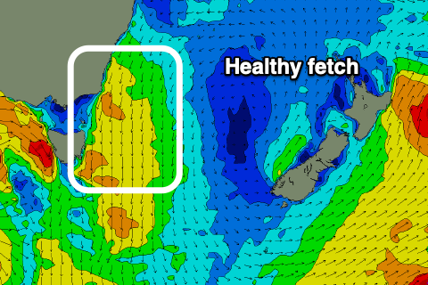
 Moving into next week we've got a better N/NE windswell on the cards for Tuesday as a deepening cold front/developing low pushes in from the west, squeezing another tight high in the Tasman Sea.
A broad and elongated fetch of N/NE winds are expected early Tuesday morning until the afternoon when the change moves through, kicking up a rapid increase in N/NE swell that should reach 3ft+ across north-east facing beaches.
Winds will be gusty from the N, shifting NW ahead of a late W/NW change. With this open beaches will be cleaner but smaller.
 In the wake of the change we'll see a broad, strong polar low likely generating some fun S'ly groundswell for Thursday/Friday. Current forecasts having it 'bombing' but more on this in Monday's update though.
Have a great weekend!

