Our attention shifts to the north
Eastern Tasmania Surf Forecast by Craig Brokensha (issued Monday 9th November)
Best Days: Northern corners for the keen late Wednesday, Thursday northern corners, Friday morning
Recap
Fun pulses of S'ly swell over the weekend, cleanest Saturday morning and again Sunday morning with the south magnets the pick.
Today we've got a reinforcing pulse of swell to a smaller 2ft with the south magnets offering the cleanest, best waves.
This week and weekend (Nov 10 - 15)
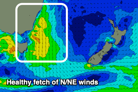
In the wake of the S'ly swell from the weekend, our attention swings to the north-east, with building levels of N/NE windswell expected across the coast from tomorrow, lasting all week.
This will be linked to a strong mid-latitude which is currently forming off the south-west tip of Western Australia slowly moving through the Bight, squeezing a strong high in the Tasman Sea.
A strengthening fetch of N/NE winds will be aimed through our swell window from tomorrow through Thursday, strongest Wednesday evening.
 This should kick up building levels of N/NE windswell, building slowly tomorrow and only likely to 2ft or so later in the day, increasing more noticeably Wednesday from 2ft to possibly 3ft to 3ft+ by dark and then peaking Thursday to 3-4ft.
Through this period strong N/NE winds are generally expected, though lighter and more N/NW each morning. Come Thursday the low will start to move across us swinging winds from the N'th to N/NW late morning and then NW late in the afternoon.
Friday will likely see persistent NW winds as the N/NE windswell starts easing back from 2-3ft or so, tiny into the weekend.
Longer term there's nothing too significant on the cards at this stage, so check back here on Wednesday for any changes to the expected wind and timing of the change.

