Mixed swells but only a couple of decent days
Eastern Tasmania Surf Forecast by Craig Brokensha (issued Monday 2nd November)
Best Days: Wednesday working the winds, Sunday morning
Recap
The fun swell from the middle to end of last week dropped back to a small 2ft Saturday with cleanest conditions in northern corners, average Sunday.
Today the swell is small and clean to 1-2ft out of the north-east from a low that's formed off the southern NSW coast.
This week and weekend (Nov 3 - 8)
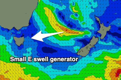
After a downgrade in strength and longevity late last week, a low that moved off the southern NSW coast during the weekend now looks to bring some fun swell out of the E over the coming days.
It's sitting just within our swell window, with a fetch of strong E/SE winds being generated over towards New Zealand.
This should produce a fun pulse of E'ly swell for late tomorrow but more so Wednesday morning with sets to 2-3ft across open beaches, with tomorrow morning being around 2ft or so.
A trough approaching from the west tomorrow will generate strengthening N'ly winds down our coast Tuesday evening and an additional N/NE windswell to 2-3ft.
Winds will be fresh and gusty from the N/NW tending N'ly tomorrow, with Wednesday being the pick with a N/NW-NW breeze, shifting NW mid-late afternoon ahead of a late S'ly change which.
 There's no swell due in the wake of this change, but moving into the weekend, a small new S'ly groundswell is due to fill in, generated by a strong polar frontal system firing up south-west of the state Friday.
It'll be fairly zonal but broad and elongated with a fetch of gale-force W/SW winds generate just within our swell window, weaker but better aligned and SW into Friday evening/Saturday morning.
A small spike in S'ly groundswell is due Saturday afternoon with sets possibly reaching 3ft, though with onshore S'ly winds. Sunday looks a touch cleaner as the swell eases back from the 3ft range. Following this it looks a little slower, but more on this in Wednesday's notes.

