Easing surf, new swell late week
Eastern Tasmanian Forecast by Craig Brokensha (issued Monday 24th August)
Best Days: Tomorrow, Friday
Recap
Saturday started small and clean, but some new S/SE-S energy kicked into the afternoon but yesterday offered the most size, cleanest in southern corners.
The swell has held well into this morning with an additional pulse from a cold front pushing up and past us yesterday, with nice, clean conditions.
This week and weekend (Aug 25 - 30)
The last couple of days of swell will ease back in size tomorrow with the slow moving low and front pushing up past us now clearing to the north-east.
We should see easing 2-3ft sets with a morning offshore, possibly giving into sea breezes though mostly likely variable.
From here there’s nothing major on the cards, with a weak mid-period S/SW swell possibly providing 1-2ft sets on the south swell magnets Wednesday afternoon, fading Thursday.
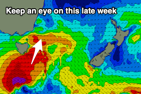
 Later in the week a better S’ly swell is on the cards as a strengthening mid-latitude front pushes up and past the south-east corner of the state. This has been upgraded in recent model runs so we’ll have to confirm it’s development on Wednesday but we should now see a good spike of S’ly swell Friday afternoon to 3-4ft across the south magnets with W/SW-W winds.
The swell will fade through Saturday from a small 1-2ft as winds shift back to the W/NW.
Longer term there’s nothing too major on the cards so make the most of tomorrow’s easing swell and check Wednesday for an update on Friday.

