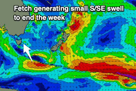
Swing in swells to the south-southeast
Eastern Tasmania Surf Forecast by Craig Brokensha (issued Wednesday 19th August)
Best Days: Tomorrow, Friday, protected spots late Saturday and Sunday, Monday
Recap
Great waves yesterday with a mix of easing E/SE swell and reinforcing E/NE swell with favourable winds. Today there should have still been plenty of size on offer, with Sydney raking in 3ft+ of swell this morning even though it was better aimed for Tasmania. Alas only 2ft of swell was reported which is a bit of a mystery.
This week and weekend (Aug 18 - 23)
With the E/NE swell dropping so much in to today, I wouldn't expect much over 1-2ft on the coast tomorrow morning.
We should see the new S/SE swell building through the afternoon though, generated by a slow moving fetch of strong to near gale-force E/SE winds through our swell window today.
 This should kick up 2-3ft of swell later tomorrow, easing Friday morning from a similar size with persistent W/NW winds tomorrow and NW winds on Friday.
Moving into the weekend and we'll see a broad low moving in from the wes, projecting a fetch of strong to near gale-force S/SE winds up and past our coast on Saturday afternoon.
The strength of this system has been downgraded and we're looking at a building S/SE swell Saturday afternoon, likely reaching 4-6ft with strong S/SW-S winds, peaking Sunday to 6ft to possibly 8ft as strong S/SW winds persist.
Monday looks much better for open beaches with easing levels of SE swell from 4ft or so with W/SW tending NE winds.
Following this, the outlook is slow with small pulses of S'ly swell the best of it. More on this Friday.

