Inconsistent north-east energy, with a windy south swell next week
Eastern Tasmania Surf Forecast by Craig Brokensha (issued Friday 31st July)
Best Days: Tomorrow morning, Tuesday, Thursday
Recap
A small 1-2ft of NE swell yesterday, tiny this morning but some new inconsistent NE energy should have kicked in this afternoon.
This week and weekend (Aug 1 - 7)
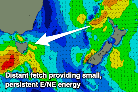
I'm a little worried about the NE swell due later today and tomorrow morning, with it not showing too well across the Sydney region today. There are infrequent 3-4ft sets showing this afternoon but it appears to be more from the infeed of E/NE winds extending out behind New Zealand rather than the intensification of NE gales down through the Tasman Sea. In saying this the projection of NE winds was more favourably aimed towards us which is a plus.
In any case I've downgraded the expected size a little for tomorrow, with infrequent 3ft sets most likely across the north-east magnets, though expect waits up to 5 minutes or so.
 The swell is due to ease through the day and hold a small and inconsistent 2ft Sunday.
Conditions will be nice and clean tomorrow morning with a freshening W/NW tending N/NW breeze, N/NW all day Sunday which isn't ideal for those north-east magnets.
The coast is unlikely to go flat early next week with small and inconsistent levels of background E/NE swell, and an additional pulse on Tuesday from an intensification of the E/NE trades north of New Zealand Sunday.
Only small 2ft+ sets are due as winds swing to the south.
This change in wind will be linked to a strong cold outbreak projecting up and across us Monday, forming into a low and then deepening significantly just off our coast.
The models are fairly solid with this outcome, and a fetch of gales are expected to be projected up and past is Wednesday. This will kick up a large and windy S'ly swell, fading rapidly Thursday as winds swing back offshore, though we'll have to review this again on Monday. Have a great weekend!

