Southerly swell developing through the weekend
Eastern Tasmania Surf Forecast by Craig Brokensha (issued Friday 1st May)
Best Days: Tomorrow, Sunday, Monday
Recap
A continuation of good sized NE swell yesterday, easing back from 2-3ft this morning.
This weekend and next week (May 2 - 8)
Now with the NE swell on the ease (generated by a north-east infeed to a strong and slow moving low that's currently to our south-west), we look to the secondary S'ly swell event due on the weekend and Monday next week.
This morning a slither of gale to severe-gale S/SE winds on the bottom flank of the low was generated just within our southern swell window and this should provide a new pulse of S'ly swell for tomorrow morning, coming in at 2-3ft on the south swell magnets.
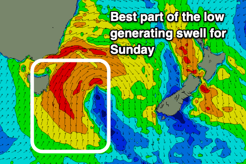
 As the day develops though we'll see the low move east and direct a fetch of S/SW gales up past us into tomorrow afternoon and evening. This will kick up some building swell later in the day, though size wise maybe reaching 4ft+ late in the day on the south swell magnets.
A peak in size is due Sunday morning still with good 5-6ft sets from a broader fetch of strong to gale-force S'ly winds opening up through our swell window, with smaller waves at other locations, easing further from 3ft to possibly 4ft dawn Monday, 2ft into the afternoon, tiny Tuesday.
Looking at the local winds and fresh to strong W/SW tending SW breezes are due tomorrow, W/NW tending SW and then S Sunday and then W/NW on Monday morning ahead of sea breezes.
Longer term there's nothing significant on the cards, so make the most of the current coming swell! Have a great weekend!

