Upgrade from the NE, followed by S
Eastern Tasmania Surf Forecast by Craig Brokensha (issued Wednesday 29th April)
Best Days: Tomorrow, Friday morning, Saturday, Sunday, Monday
Recap
Tiny yesterday's but today we've seen our building N/NE swell with some decent size already at dawn. This is due to the earlier evolution of the N/NE fetch north-east of us and with it strengthening through today, more size should be seen this afternoon.
This week and weekend (Apr 25 – May 1)
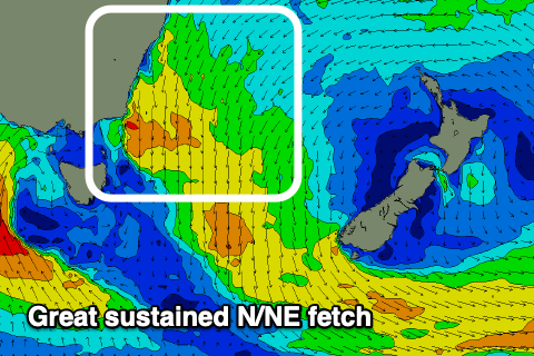
We've got a clearer idea on the strength, longevity and depth of the N/NE swell generating fetch that's currently developed to our north-east and it's looking much more robust than it was on Monday.
 This will result in an upgrade in the expected size, with strengthening N/NE winds this evening and early tomorrow morning across the same stretch of ocean now expected to produce a good NE groundswell that should peak tomorrow.
Size wise it now looks like we'll see 4-5ft surf develop through the day, with 6ft sets on the magnets and winds will shift offshore from the NW and hold all day.
We'll see the swell easing Friday from at least 3ft, if not for the odd bigger one on the swell magnets.
Winds will be offshore out of the W/NW, strengthening from the N/NW-NW through the day.
 Come the weekend most of the NE swell will be gone, though there should be some distant and inconsistent E/NE trade-swell in the mix. Of greater importance is the S'ly swell from the strong and intense low moving in from our west.
As this low develops and stalls tomorrow and Friday a slither of S/SE gales will be aimed just in our southern swell window and we may see this offer 2-3ft sets across the south swell magnets Saturday morning, but the western arm of the low will push up and past our coast through the day.
This will bring gale to severe-gale S/SW winds right off our coast, producing a large building S'ly swell that's expected to peak Sunday morning. Saturday should see the surf kicking to 4-5ft late, better Sunday and to 6ft+ on the south swell magnets, much smaller at other breaks.
Winds look OK and strong W tending W/SW winds on Saturday, lighter W/NW tending S/SW on Sunday.
Into next week the swell will slowly tail away with offshore morning W'ly winds ahead of afternoon sea breezes.

