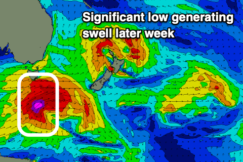
Good S'ly groundswell later week
Eastern Tasmania Surf Forecast by Craig Brokensha (issued Monday 3rd June)
Best Days: Thursday, Friday south swell magnets
Recap
Friday's large S/SE groundswell remained so into Saturday morning with light offshore winds and easing surf from 4-6ft, back to 3-4ft on Sunday with great conditions again.
Today onshore winds were back in as a strong low moved off the coast north of us creating poor conditions.
Today’s Forecaster Notes are brought to you by Rip Curl
This week and weekend (Jun 4 - 9)
The low that's moved off the coast to our north isn’t expected to generate any meaningful swell as it aims strong S/SE winds along our coast, persisting tomorrow before the low slides off to the east-northeast Wednesday.
Just a junky 2-3ft of S/SE windswell is expected tomorrow with strong S/SW winds, cleaner and easing from 2ft on Wednesday morning at south swell magnets with a W/NW offshore.
 Of greater importance is a significant polar low that's due to form right under the state on Wednesday, projecting a fetch of severe-gale to storm-force W/SW tending SW winds through our swell window as it projects closer to and then over New Zealand.
This will generate a large S'ly groundswell for Thursday, peaking into the afternoon to 5-6ft across south swell magnets, smaller at other breaks and smaller in the morning.
Winds will shift from the W/SW-SW which isn't ideal but we may see them tending variable later, favouring most breaks.
Friday looks great for south magnets with a N/NW tending NE breeze as the S'ly groundswell eases rapidly from 4ft on the sets, down to 2ft into the afternoon.
We may see a secondary pulse of smaller S'ly groundswell for Saturday from a strong but zonal polar low later week, though the latest data isn't too amazing. Beyond this there's nothing too significant on the cards so try and make the most of the swell late week.

